IMAGES TAKEN NEAR TO
Milnathort, KINROSS, KY13 9SH
Introduction
This page details the photographs taken nearby to KY13 9SH by members of the Geograph project.
The Geograph project started in 2005 with the aim of publishing, organising and preserving representative images for every square kilometre of Great Britain, Ireland and the Isle of Man.

There are currently over 7.5m images from over14,400 individuals and you can help contribute to the project by visiting https://www.geograph.org.uk
Image Map
Images are licensed for reuse under creativecommons.org/licenses/by-sa/2.0
Notes
- Clicking on the map will re-center to the selected point.
- The higher the marker number, the further away the image location is from the centre of the postcode.
Image Listing (8 Images Found)
Images are licensed for reuse under creativecommons.org/licenses/by-sa/2.0
Image
Details
Distance
1
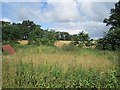
An unused patch
Opposite Southfield with a barley field beyond. The M90 is very audible.
Image: © Richard Webb
Taken: 30 Jul 2012
0.08 miles
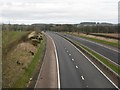
2
Woodland, Southfield
A wood opposite a big new byre.
Image: © Richard Webb
Taken: 30 Jul 2012
0.09 miles
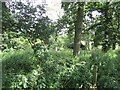
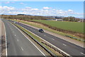
4
Farmland near Glen Farg
Arable land in various states of tillage
Image: © Paul McIlroy
Taken: 6 May 2008
0.15 miles
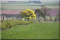
5
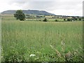
Barley field
A view towards Bishop Hill.
Image: © Richard Webb
Taken: 30 Jul 2012
0.20 miles
7
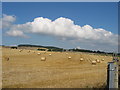
Harvest scene on the Kinross/Fife border
Photographed from the A91 SW of Burnside
Image: © Brian D Osborne
Taken: 6 Sep 2005
0.24 miles
