IMAGES TAKEN NEAR TO
Cuthill Towers, KINROSS, KY13 9SE
Introduction
This page details the photographs taken nearby to Cuthill Towers, KY13 9SE by members of the Geograph project.
The Geograph project started in 2005 with the aim of publishing, organising and preserving representative images for every square kilometre of Great Britain, Ireland and the Isle of Man.

There are currently over 7.5m images from over14,400 individuals and you can help contribute to the project by visiting https://www.geograph.org.uk
Image Map
Images are licensed for reuse under creativecommons.org/licenses/by-sa/2.0
Notes
- Clicking on the map will re-center to the selected point.
- The higher the marker number, the further away the image location is from the centre of the postcode.
Image Listing (3 Images Found)
Images are licensed for reuse under creativecommons.org/licenses/by-sa/2.0
Image
Details
Distance
1
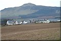
Housing at Cuthill Towers
New housing and renovation of farm buildings at Cuthill Towers farm.
Image: © Alfred Fyfe
Taken: 4 Mar 2007
0.06 miles
2
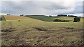
The silage is in
Evidence of another wet summer, but the silage crop has been gathered. Near Cuthill Towers.
Image: © Richard Webb
Taken: 30 Jul 2012
0.16 miles
3
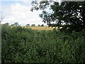
Overgrown gate
This gate probably has not been opened for a while. A legacy of livestock farming days and smaller fields?
Image: © Richard Webb
Taken: 30 Jul 2012
0.22 miles