IMAGES TAKEN NEAR TO
Dryside Road, KINROSS, KY13 9ND
Introduction
This page details the photographs taken nearby to Dryside Road, KY13 9ND by members of the Geograph project.
The Geograph project started in 2005 with the aim of publishing, organising and preserving representative images for every square kilometre of Great Britain, Ireland and the Isle of Man.

There are currently over 7.5m images from over14,400 individuals and you can help contribute to the project by visiting https://www.geograph.org.uk
Image Map
Images are licensed for reuse under creativecommons.org/licenses/by-sa/2.0
Notes
- Clicking on the map will re-center to the selected point.
- The higher the marker number, the further away the image location is from the centre of the postcode.
Image Listing (11 Images Found)
Images are licensed for reuse under creativecommons.org/licenses/by-sa/2.0
Image
Details
Distance
1
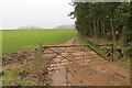
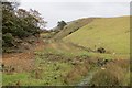
Runoff, Glenlomond
A lot of sandy soil has been washed off the field here.
An earlier view: Image
Image: © Richard Webb
Taken: 1 Feb 2014
0.08 miles
2
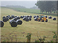
Collecting bales
Farming work must go on, no matter the weather.
Stacking the bales: http://www.geograph.org.uk/photo/562752
Image: © Simon Johnston
Taken: 30 Jun 2007
0.09 miles
3
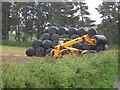
Stacking bales
Agricultural machinery makes logistics easier on the farm especially during inclement weather.
collecting bales http://www.geograph.org.uk/photo/562748
Image: © Simon Johnston
Taken: 30 Jun 2007
0.09 miles
4
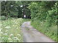
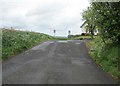
Dryside Road
The minor road heading to Glenlomond.
Image: © Scott Cormie
Taken: 16 Jul 2017
0.10 miles
5
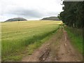
Farm track, Glenlomond
Barley and track with West Lomond on the left of the background. The trees line the grounds of Glenlomond, a former sanatorium and now a nursing home.
Image: © Richard Webb
Taken: 31 Jul 2009
0.11 miles
6
Dryside road, Lomond Hills
Dryside Road Image] continues straight ahead. From this point the road is a narrow single-track road with very few passing places. It is well used by walkers, cyclists and other traffic and drivers should exercise care. The turning to the right leads to the small village of Glenlomond.
See Lomond Hills Regional Park article http://www.geograph.org.uk/article/Lomond-Hills-Regional-Park
Image: © Bill Kasman
Taken: 21 May 2017
0.13 miles
7
Glenlomond
Farm track at the foot of the Lomond Hills.
Image: © Richard Webb
Taken: 1 Feb 2014
0.16 miles
8
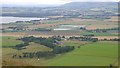
Glenlomond
The site of Glenlomond Hospital and Loch Leven seen from Bishop Hill.
Image: © Richard Webb
Taken: 14 Aug 2016
0.19 miles
9
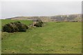
Track, Glenlomond
Hummocky ground at the foot of the Lomond Hills.
Image: © Richard Webb
Taken: 1 Feb 2014
0.19 miles
10
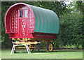
Gipsy Caravan
To avoid disappointment, this is not a "caravan site" but it is the "site of a caravan". The sight of this gipsy caravan is not disappointing.
(may also be spelled gypsy caravan)
Image: © Simon Johnston
Taken: 30 Jun 2007
0.21 miles