IMAGES TAKEN NEAR TO
Anderson Drive, KY13 9AD
Introduction
This page details the photographs taken nearby to Anderson Drive, KY13 9AD by members of the Geograph project.
The Geograph project started in 2005 with the aim of publishing, organising and preserving representative images for every square kilometre of Great Britain, Ireland and the Isle of Man.

There are currently over 7.5m images from over14,400 individuals and you can help contribute to the project by visiting https://www.geograph.org.uk
Image Map
Images are licensed for reuse under creativecommons.org/licenses/by-sa/2.0
Notes
- Clicking on the map will re-center to the selected point.
- The higher the marker number, the further away the image location is from the centre of the postcode.
Image Listing (13 Images Found)
Images are licensed for reuse under creativecommons.org/licenses/by-sa/2.0
Image
Details
Distance
1
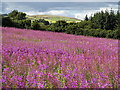
Field near Hattonburn Bridge
Rosebay willowherb (Chamerion angustifolium) growing on a field near Hattonburn bridge. I do not know whether the plant was cultivated or if it has self seeded, but its prolific growth has virtually covered the entire field.
Image: © William Starkey
Taken: 12 Aug 2013
0.08 miles
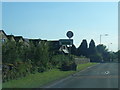
2
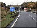
M90 Approaching Milnathort
The southbound M90, approaching junction 7.
Image: © David Dixon
Taken: 26 Oct 2011
0.10 miles
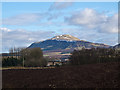
3
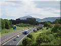
M90 at Milnathort
The M90 to the north of Milnathort, with West Lomond in the distance.
Image: © Scott Cormie
Taken: 23 Jul 2019
0.11 miles
4
Field near Hattonburn Bridge
Rosebay willowherb (Chamerion angustifolium) growing on a field near Hattonburn Bridge, with Bishop Hill in the background.
Image: © William Starkey
Taken: 12 Aug 2013
0.13 miles
5

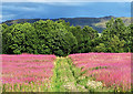
Field near Hattonburn Bridge
Rosebay willowherb (Chamerion angustifolium) growing on a field near Hattonburn Bridge, with West Lomond in the background.
Image: © William Starkey
Taken: 12 Aug 2013
0.15 miles
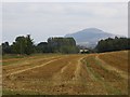
7
Farmland on Pace Hill
Recently ploughed farmland at Pace Hill to the north of Milnathort. West Lomond Hill dominates the skyline here, and still carries traces of snow after recent cold weather.
Image: © William Starkey
Taken: 15 Feb 2013
0.17 miles
9
Pace Hill
Oat straw with the M90 in a cutting to the left.
Image: © Richard Webb
Taken: 1 Oct 2013
0.18 miles
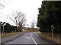
10
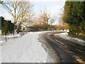
Link to the Old Perth Road
Road between the Old and New Perth Roads. The Old Perth Road was realigned as part of the M90(within earshot) construction.
Image: © Richard Webb
Taken: 7 Jan 2010
0.19 miles