IMAGES TAKEN NEAR TO
Latch Dubh Lane, KINROSS, KY13 8GQ
Introduction
This page details the photographs taken nearby to Latch Dubh Lane, KY13 8GQ by members of the Geograph project.
The Geograph project started in 2005 with the aim of publishing, organising and preserving representative images for every square kilometre of Great Britain, Ireland and the Isle of Man.

There are currently over 7.5m images from over14,400 individuals and you can help contribute to the project by visiting https://www.geograph.org.uk
Image Map
Images are licensed for reuse under creativecommons.org/licenses/by-sa/2.0
Notes
- Clicking on the map will re-center to the selected point.
- The higher the marker number, the further away the image location is from the centre of the postcode.
Image Listing (8 Images Found)
Images are licensed for reuse under creativecommons.org/licenses/by-sa/2.0
Image
Details
Distance
1
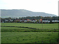
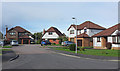
Lathro Housing Estate
View east to northern edge of current Kinross housing Bishop Hill in background
Image: © Alfred Fyfe
Taken: 29 Oct 2006
0.11 miles
2
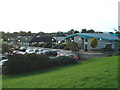
Health Centre and Leisure Centre
Loch Leven Health Centre (to left) and Loch Leven Leisure (to right) on North edge of Lathro housing estate.
Image: © Alfred Fyfe
Taken: 29 Oct 2006
0.11 miles
3
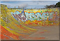
Skateboard ramp
A graffiti-covered skateboard ramp in Kinross.
Image: © William Starkey
Taken: 22 Mar 2011
0.17 miles
5
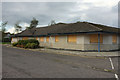
Former Loch Leven Health Centre
The old health centre building looks to be in good condition, but was "cramped and ... inadequate for current demand and ... unsuitable for expansion".
Image: © Rob Burke
Taken: 17 Sep 2011
0.19 miles
7
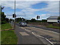
The A922 passing Loch Leven school, looking north
Image: © Rob Purvis
Taken: 22 Jun 2018
0.21 miles
8

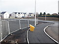
Building site, Gallowhill Road
Filling in inside the M90.
Image: © Richard Webb
Taken: 5 Feb 2023
0.22 miles