IMAGES TAKEN NEAR TO
Montgomery Street, KINROSS, KY13 8EB
Introduction
This page details the photographs taken nearby to Montgomery Street, KY13 8EB by members of the Geograph project.
The Geograph project started in 2005 with the aim of publishing, organising and preserving representative images for every square kilometre of Great Britain, Ireland and the Isle of Man.

There are currently over 7.5m images from over14,400 individuals and you can help contribute to the project by visiting https://www.geograph.org.uk
Image Map
Images are licensed for reuse under creativecommons.org/licenses/by-sa/2.0
Notes
- Clicking on the map will re-center to the selected point.
- The higher the marker number, the further away the image location is from the centre of the postcode.
Image Listing (53 Images Found)
Images are licensed for reuse under creativecommons.org/licenses/by-sa/2.0
Image
Details
Distance
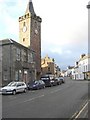
2
Kinross High Street.
Looking South, the clock tower is the old Town House which is no longer in use.
Image: © Paul McIlroy
Taken: 17 Dec 2005
0.12 miles
3
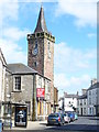
Kinross Steeple
The steeple is the last reminder of the 1741 parish church.
http://www.kinross.cc/
Image: © Colin Smith
Taken: 13 Aug 2009
0.12 miles
4

Urban art and road sign, Swansacre, Kinross
This artwork on a hoarding around a disused building on Swansacre was painted by volunteers from KLEO (Kinross-shire Local Events Organisation). The building is scheduled for conversion into housing association dwellings.
Image: © William Starkey
Taken: 30 Sep 2010
0.12 miles
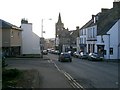
5
Brewery Lane
Narrow street off the High Street, Kinross.
Image: © Richard Webb
Taken: 3 Jul 2009
0.12 miles
6
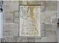
Former library and museum at Kinross - plaque
The inscription on the plaque reads:-
"To the citizens of Kinross, Milnathort and Kelty, in gratitude for the hospitality received by Polish Tank Training Centre 1942-1948."
Image: © Euan Nelson
Taken: 19 Apr 2015
0.12 miles
7
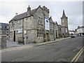
Former library and museum, Kinross
This former library and museum dates from 1905, and was one of hundreds of libraries funded by the Dunfermline-born philanthropist, Andrew Carnegie, a man who made his fortune in the American steel industry. The property has now been converted into luxury flats.
Image: © Euan Nelson
Taken: 19 Apr 2015
0.12 miles
8
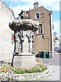
Fountain, Kinross
Ornate old stone fountain (1886) on the west side of Kinross High Street. It is sited over an even older public well.
http://www.kinross.cc/
Image: © Colin Smith
Taken: 13 Aug 2009
0.13 miles
9
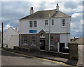
Cadet Centre, Swansacre
The Cadet Centre in Swansacre, Kinross, formerly the drill station of the 7th Battalion, Argyll & Sutherland Highlanders (G Company) and Fife & Forfar Yeomanry (B Squadron).
See also:
Geograph Collection "WW1 Great War Centenary - Drill Halls"
http://www.geograph.org.uk/article/WW1-Great-War-Centenary---Drill-Halls/
Drill Hall Project
http://www.drillhalls.org/index.htm
Image: © William Starkey
Taken: 13 Aug 2014
0.13 miles
10
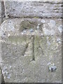
Ordnance Survey Rivet
This OS rivet can be found on the front of the Drill Hall. It marks a point 116.562m above mean sea level.
Image: © Adrian Dust
Taken: 16 Apr 2016
0.13 miles