IMAGES TAKEN NEAR TO
Morlich Place, KINROSS, KY13 8BW
Introduction
This page details the photographs taken nearby to Morlich Place, KY13 8BW by members of the Geograph project.
The Geograph project started in 2005 with the aim of publishing, organising and preserving representative images for every square kilometre of Great Britain, Ireland and the Isle of Man.

There are currently over 7.5m images from over14,400 individuals and you can help contribute to the project by visiting https://www.geograph.org.uk
Image Map
Images are licensed for reuse under creativecommons.org/licenses/by-sa/2.0
Notes
- Clicking on the map will re-center to the selected point.
- The higher the marker number, the further away the image location is from the centre of the postcode.
Image Listing (7 Images Found)
Images are licensed for reuse under creativecommons.org/licenses/by-sa/2.0
Image
Details
Distance
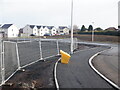
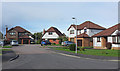
6

Building site, Gallowhill Road
Filling in inside the M90.
Image: © Richard Webb
Taken: 5 Feb 2023
0.24 miles
7
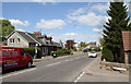
Muirs
On the outskirts of Kinross - The A922 seen at the junction with Sunnypark.
Image: © Martin Addison
Taken: 3 May 2011
0.24 miles