IMAGES TAKEN NEAR TO
Naemoor Road, KINROSS, KY13 0UG
Introduction
This page details the photographs taken nearby to Naemoor Road, KY13 0UG by members of the Geograph project.
The Geograph project started in 2005 with the aim of publishing, organising and preserving representative images for every square kilometre of Great Britain, Ireland and the Isle of Man.

There are currently over 7.5m images from over14,400 individuals and you can help contribute to the project by visiting https://www.geograph.org.uk
Image Map
Images are licensed for reuse under creativecommons.org/licenses/by-sa/2.0
Notes
- Clicking on the map will re-center to the selected point.
- The higher the marker number, the further away the image location is from the centre of the postcode.
Image Listing (6 Images Found)
Images are licensed for reuse under creativecommons.org/licenses/by-sa/2.0
Image
Details
Distance
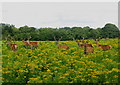
1

Monarch Deer Park
The trees are showing signs of attention from antler scratching stags. The deer were some distance away across the park.
Image: © Richard Webb
Taken: 14 Sep 2013
0.06 miles
2
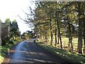
Lendrick Muir road, Crook of Devon
Deer park on the right.
Image: © Richard Webb
Taken: 1 Dec 2021
0.16 miles
3
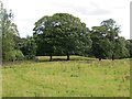
Monarch Deer Park
The east end of a field in a deer farm.
Image: © Richard Webb
Taken: 14 Sep 2013
0.21 miles
4
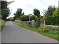
Path end, Crook of Devon
Signposted path heading north.
Image: © Richard Webb
Taken: 14 Sep 2013
0.22 miles
5
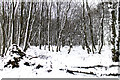
Path in Lendrick Muir woodland
A faint path through the forest on the Lendrick Muir estate. The temperature has fallen for a brief period in early March, and the forest floor, and the sides of trees facing the prevailing wind are snow covered.
Image: © William Starkey
Taken: 3 Mar 2015
0.25 miles