IMAGES TAKEN NEAR TO
Rumbling Bridge, KINROSS, KY13 0PS
Introduction
This page details the photographs taken nearby to KY13 0PS by members of the Geograph project.
The Geograph project started in 2005 with the aim of publishing, organising and preserving representative images for every square kilometre of Great Britain, Ireland and the Isle of Man.

There are currently over 7.5m images from over14,400 individuals and you can help contribute to the project by visiting https://www.geograph.org.uk
Image Map
Images are licensed for reuse under creativecommons.org/licenses/by-sa/2.0
Notes
- Clicking on the map will re-center to the selected point.
- The higher the marker number, the further away the image location is from the centre of the postcode.
Image Listing (7 Images Found)
Images are licensed for reuse under creativecommons.org/licenses/by-sa/2.0
Image
Details
Distance
1
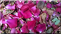
Fallen rose petals
Petals from a climbing rose - still beautiful when fallen and in decay. My only submission to Geograph taken on a cameraphone.
Image: © William Starkey
Taken: 20 Jul 2014
0.04 miles
2
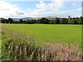
Grassland beside the Devon
View towards Seamab Hill.
Image: © Richard Webb
Taken: 14 Sep 2013
0.16 miles
3
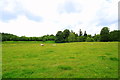
Grazing land by the River Devon.
Sheep grazing by the River Devon footpath.
Image: © edward mcmaihin
Taken: 12 Jun 2011
0.20 miles
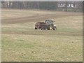
4
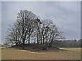
Farmland by the River Devon
This tree-covered mound is visible from the Crook of Devon millennium footpath network
Image: © William Starkey
Taken: 20 Feb 2011
0.21 miles
5
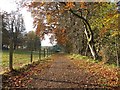
River Devon path
A relatively new path following the south bank of the River Devon.
Image: © Callum Black
Taken: 4 Nov 2012
0.24 miles
6
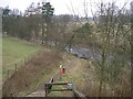
Path
It runs alongside the Devon from Crook of Devon to Rumbling Bridge.
Image: © Paul McIlroy
Taken: 2 Feb 2006
0.24 miles