IMAGES TAKEN NEAR TO
Carnbo, KINROSS, KY13 0NX
Introduction
This page details the photographs taken nearby to KY13 0NX by members of the Geograph project.
The Geograph project started in 2005 with the aim of publishing, organising and preserving representative images for every square kilometre of Great Britain, Ireland and the Isle of Man.

There are currently over 7.5m images from over14,400 individuals and you can help contribute to the project by visiting https://www.geograph.org.uk
Image Map
Images are licensed for reuse under creativecommons.org/licenses/by-sa/2.0
Notes
- Clicking on the map will re-center to the selected point.
- The higher the marker number, the further away the image location is from the centre of the postcode.
Image Listing (7 Images Found)
Images are licensed for reuse under creativecommons.org/licenses/by-sa/2.0
Image
Details
Distance
1
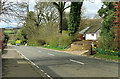
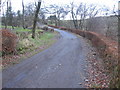
Carnbo village
A tiny settlement on the A91 near Kinross.
Image: © Mary and Angus Hogg
Taken: 4 Apr 2024
0.01 miles
2
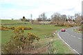
Whins and grass by Carnbo
Looking east at the western edge of Carnbo and along the A91.
Image: © Jim Bain
Taken: 26 Apr 2006
0.12 miles

4
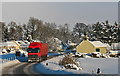
HGV at Carnbo
Following recent severe weather, a large truck proceeds carefully through the village of Carnbo (Carn + bo: cairn of the cows; a place where cattle were driven for safety in times of danger).
Image: © William Starkey
Taken: 1 Dec 2010
0.14 miles
7
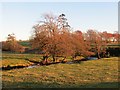
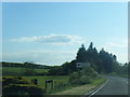
South Queich, Carnbo
A Winter afternoon, unusual in that there was no clouds in the southwest. The burn is flanked by alders.
Image: © Richard Webb
Taken: 22 Nov 2013
0.23 miles