IMAGES TAKEN NEAR TO
KINROSS, KY13 0LE
Introduction
This page details the photographs taken nearby to KY13 0LE by members of the Geograph project.
The Geograph project started in 2005 with the aim of publishing, organising and preserving representative images for every square kilometre of Great Britain, Ireland and the Isle of Man.

There are currently over 7.5m images from over14,400 individuals and you can help contribute to the project by visiting https://www.geograph.org.uk
Image Map
Images are licensed for reuse under creativecommons.org/licenses/by-sa/2.0
Notes
- Clicking on the map will re-center to the selected point.
- The higher the marker number, the further away the image location is from the centre of the postcode.
Image Listing (5 Images Found)
Images are licensed for reuse under creativecommons.org/licenses/by-sa/2.0
Image
Details
Distance
1
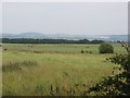
Grassland, Gellybank
Fodder awaiting harvest. Smoke visible from a fire somewhere on the slopes of the Ochils above Milnathort.
Image: © Richard Webb
Taken: 3 Jul 2009
0.08 miles
2
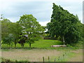
Trees around Chance Inn House
The house itself is in the neighbouring square.
Image: © James Allan
Taken: 23 Jun 2014
0.14 miles
3
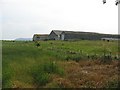
Chance Inn
On recent maps, this farm was labelled as a pub. The error has now been corrected.
Image: © Richard Webb
Taken: 3 Jul 2009
0.20 miles
4
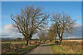
North Sea cycle route
A quiet section of the North Sea cycle route near Kinross. This 6000km cycle route passes through eight countries (England, Scotland, Germany, Netherlands, Belgium, Denmark, Sweden, Norway) and the complete circuit involves several ferry crossings. More information can be found on: http://www.northsea-cycle.com/default.asp?lang=1&alevel=x-small
Image: © William Starkey
Taken: 22 Mar 2011
0.23 miles
5
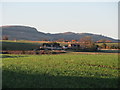
Gellybank Farm
A distant view of Gellybank Farm, with the Cleish Hills beyond.
Image: © Scott Cormie
Taken: 28 Oct 2018
0.24 miles