IMAGES TAKEN NEAR TO
St. Clair Terrace, Boreland, KIRKCALDY, KY1 2YJ
Introduction
This page details the photographs taken nearby to St. Clair Terrace, Boreland, KY1 2YJ by members of the Geograph project.
The Geograph project started in 2005 with the aim of publishing, organising and preserving representative images for every square kilometre of Great Britain, Ireland and the Isle of Man.

There are currently over 7.5m images from over14,400 individuals and you can help contribute to the project by visiting https://www.geograph.org.uk
Image Map
Images are licensed for reuse under creativecommons.org/licenses/by-sa/2.0
Notes
- Clicking on the map will re-center to the selected point.
- The higher the marker number, the further away the image location is from the centre of the postcode.
Image Listing (13 Images Found)
Images are licensed for reuse under creativecommons.org/licenses/by-sa/2.0
Image
Details
Distance
1
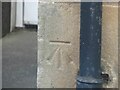
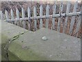
Benchmark on former Boreland Primary School
Ordnance Survey benchmark described on database at https://www.bench-marks.org.uk/bm139566. See also Image
Image: © Becky Williamson
Taken: 17 Jan 2021
0.12 miles
2
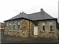
Former Boreland Primary School, Dysart
There is an Ordnance Survey benchmark on this building. See Image
Image: © Becky Williamson
Taken: 17 Jan 2021
0.12 miles
3
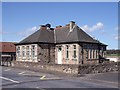
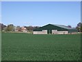
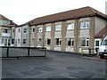
Former Boreland Primary School
Boreland primary school is now a "secondary behaviour support centre".
Image: © Ian Calderwood
Taken: 28 Apr 2012
0.12 miles
4
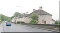
Boreland
Boreland by Dysart. Looking North along the main road.
Image: © Jim Bain
Taken: 3 Jan 2006
0.12 miles
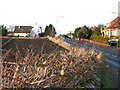
6
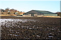
Ploughed field in Boreland
A ploughed field in Boreland on the outskirts of Kirkcaldy.
Image: © Colin Kinnear
Taken: 15 Dec 2010
0.17 miles
7
Bolt benchmark on Randolph Road railway bridge, Gallatown
Rather beautiful OSBM bolt on railway bridge, described on database at https://www.bench-marks.org.uk/bm17836.
Image: © Becky Williamson
Taken: 17 Jan 2021
0.17 miles
8
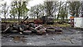
Randolph Industrial Estate
Land use in one of the units on the industrial estate, Gallatown, on the eastern edge of Kirkcaldy. Football fields on the other side of the fence.
Image: © Jim Bain
Taken: 12 Apr 2012
0.18 miles
9
Randolph Road, Kirkcaldy
Houses on the very busy A915.
Image: © Richard Webb
Taken: 29 May 2012
0.18 miles
10
Old folks home
This residential home in Boreland was originally built as a Motel but changed its function later.
Image: © James Allan
Taken: 19 Feb 2006
0.19 miles