IMAGES TAKEN NEAR TO
Dovecot Crescent, KIRKCALDY, KY1 2SJ
Introduction
This page details the photographs taken nearby to Dovecot Crescent, KY1 2SJ by members of the Geograph project.
The Geograph project started in 2005 with the aim of publishing, organising and preserving representative images for every square kilometre of Great Britain, Ireland and the Isle of Man.

There are currently over 7.5m images from over14,400 individuals and you can help contribute to the project by visiting https://www.geograph.org.uk
Image Map
Images are licensed for reuse under creativecommons.org/licenses/by-sa/2.0
Notes
- Clicking on the map will re-center to the selected point.
- The higher the marker number, the further away the image location is from the centre of the postcode.
Image Listing (33 Images Found)
Images are licensed for reuse under creativecommons.org/licenses/by-sa/2.0
Image
Details
Distance
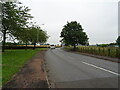
1

Former colliery line footpath
This footpath is on the line of the former railway to the Frances Colliery, a.k.a "The Dubbie"
Image: © Ian Calderwood
Taken: 28 Apr 2012
0.06 miles
3

Erdington Place and the Fife Coastal Path at Dysart
Image: © Mat Fascione
Taken: 22 Jul 2019
0.13 miles
4

The Frances Colliery Memorial
The Frances Colliery operated here between 1873 and 1985. The memorial is to the 37 men who lost their lives working there during that time.
Image: © Graham Hogg
Taken: 18 Nov 2018
0.13 miles
5

Frances Colliery Memorial, Dysart
Known locally as "The Dubbie" because of the wet conditions underground, Frances Colliery was sunk c.1850 and production continued until 1985. Three years later, the colliery closed for good.
Image: © Euan Nelson
Taken: 28 Mar 2013
0.13 miles
6
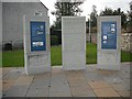
Frances Colliery Memorial
Memorial with information on the nearby colliery which closed after the 1984-85 strike.
Image: © Richard Webb
Taken: 20 Sep 2009
0.14 miles
7

Dysart - Frances Colliery Memorial
Nearby, the winding gear of the former Frances Colliery is still in place but the pit finally closed in 1985 with hundreds of job losses. A cliff top memorial listed all the miners that died during its operation. One of the main problems in the mine was high levels of carbon monoxide.
Image: © Colin Park
Taken: 23 Sep 2021
0.14 miles
8

Frances Colliery Memorial
On the clifftop beside the Fife Coastal Path. The centre piece reads:
"Dedicated to the men and women who wrocht at Frances Colliery from 1873"
Image: © Oliver Dixon
Taken: 25 Mar 2022
0.14 miles
9

The Frances Colliery Memorial
The Frances Colliery opened in 1873 and closed in 1985. The memorial is dedicated to the men and women who worked at the colliery, and the 37 who lost their lives.
The memorial lies along the Fife Coastal Path.
Image: © Mat Fascione
Taken: 22 Jul 2019
0.15 miles
10

Former colliery branch line and sidings
This short branch used to lead to the Frances Colliery, a.k.a. "The Dubbie". The exchange sidings were to the left.
Image: © Ian Calderwood
Taken: 28 Apr 2012
0.15 miles