IMAGES TAKEN NEAR TO
Dysart Road, KIRKCALDY, KY1 2BA
Introduction
This page details the photographs taken nearby to Dysart Road, KY1 2BA by members of the Geograph project.
The Geograph project started in 2005 with the aim of publishing, organising and preserving representative images for every square kilometre of Great Britain, Ireland and the Isle of Man.

There are currently over 7.5m images from over14,400 individuals and you can help contribute to the project by visiting https://www.geograph.org.uk
Image Map
Images are licensed for reuse under creativecommons.org/licenses/by-sa/2.0
Notes
- Clicking on the map will re-center to the selected point.
- The higher the marker number, the further away the image location is from the centre of the postcode.
Image Listing (37 Images Found)
Images are licensed for reuse under creativecommons.org/licenses/by-sa/2.0
Image
Details
Distance
1
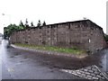
Sinclairtown Station
Closed in late 1969, the building burnt down either at the time or not long after. This is within the early childhood memory of the photographer but not enough to pin down the date.
Image: © Ian Calderwood
Taken: 8 Jun 2010
0.10 miles
2
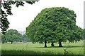
Ravenscraig Parkland
From the SE edge of the more open area of the park with playing fields a lone trees.
Image: © Jim Bain
Taken: 3 Jun 2007
0.12 miles
3
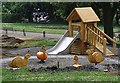
Brian and friends
The children's play park in Ravenscraig Park is being spruced up with new things being added for the smaller children. During the night the yob element had fun pushing down the Heras fencing behind slide.
Image: © Jim Bain
Taken: 3 Jun 2007
0.14 miles
4
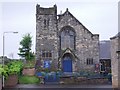
Pathhead Baptist Church
The steeple used to be higher which is why it now looks somewhat truncated.
Image: © Ian Calderwood
Taken: 8 Jun 2010
0.15 miles
5
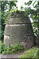
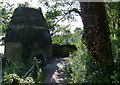
Ravenscraig Doocot
This is a beehive doocot, one of the traditional styles of doocot. It has become rather overgrown and would be the better of a tidy-up and some information.
Image: © Anne Burgess
Taken: 14 Jun 2010
0.15 miles
6
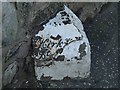
Old Milestone by the A955, near Ravenscraig Castle
A type milestone by the A955, in parish of Dysart (Fife District), Ravenscraig Castle, by wall. Metal cap broken.
Inscription reads:-
: Kirky (1) / Bt Id (?) : : (Leven 8) :
Surveyed
Milestone Society National ID: FF_KCBH01
Image: © Milestone Society
Taken: Unknown
0.16 miles
7
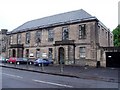
Sinclairtown Library
The building also contains the Loughborough Road Clinic.
Image: © Ian Calderwood
Taken: 8 Jun 2010
0.18 miles
8
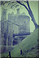
Ravenscraig Castle
Round tower at this Kirkcaldy castle which was built in 1460 for James II.
http://www.historic-scotland.gov.uk/propertyplan/propertydetail.htm?PropID=PL_230&PropName=Ravenscraig%20Castle
Image: © Colin Smith
Taken: 15 Aug 1986
0.18 miles
9
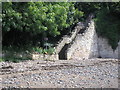
Fife Coastal Path
The view of the steps which takes the Fife Coastal Path up to Ravenscraig Park.
Image: © Sandy Gemmill
Taken: 10 Aug 2017
0.19 miles