IMAGES TAKEN NEAR TO
Spencer Place, KIRKCALDY, KY1 2AX
Introduction
This page details the photographs taken nearby to Spencer Place, KY1 2AX by members of the Geograph project.
The Geograph project started in 2005 with the aim of publishing, organising and preserving representative images for every square kilometre of Great Britain, Ireland and the Isle of Man.

There are currently over 7.5m images from over14,400 individuals and you can help contribute to the project by visiting https://www.geograph.org.uk
Image Map
Images are licensed for reuse under creativecommons.org/licenses/by-sa/2.0
Notes
- Clicking on the map will re-center to the selected point.
- The higher the marker number, the further away the image location is from the centre of the postcode.
Image Listing (107 Images Found)
Images are licensed for reuse under creativecommons.org/licenses/by-sa/2.0
Image
Details
Distance
2
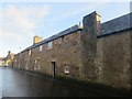
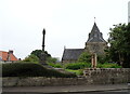
Dysart Art Club
There is an Ordnance Survey benchmark on this building. See Image
Image: © Becky Williamson
Taken: 8 Dec 2019
0.11 miles
6

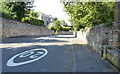
Cycleway and footpath at Dysart
This path is on the edge of Ravenscraig Park, about to join the A955 Dysart Road.
Image: © Mat Fascione
Taken: 22 Jul 2019
0.12 miles

9

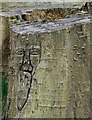
Benchmark on Art Club, Dysart
Ordnance Survey benchmark on Art Club building in Dysart. See also Image
Image: © Becky Williamson
Taken: 8 Dec 2019
0.12 miles
10
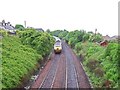
Heading North
The Edinburgh and Northern Railway has been here since 1847.
Image: © Ian Calderwood
Taken: 8 Jun 2010
0.12 miles