IMAGES TAKEN NEAR TO
Eastercraig Gardens, DUNFERMLINE, KY12 9TH
Introduction
This page details the photographs taken nearby to Eastercraig Gardens, KY12 9TH by members of the Geograph project.
The Geograph project started in 2005 with the aim of publishing, organising and preserving representative images for every square kilometre of Great Britain, Ireland and the Isle of Man.

There are currently over 7.5m images from over14,400 individuals and you can help contribute to the project by visiting https://www.geograph.org.uk
Image Map
Images are licensed for reuse under creativecommons.org/licenses/by-sa/2.0
Notes
- Clicking on the map will re-center to the selected point.
- The higher the marker number, the further away the image location is from the centre of the postcode.
Image Listing (18 Images Found)
Images are licensed for reuse under creativecommons.org/licenses/by-sa/2.0
Image
Details
Distance
1
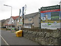
'The Views' at Saline
New housing on a 2-3-year old development on the south side of the village.
Image: © M J Richardson
Taken: 8 Oct 2019
0.10 miles
2
Saline Primary School and its "Sitooterie"
Looks like Colditz. I'll bet that's what the primary school kids think too. However you might just be able to make out an interesting wee building in front of the main school....it's a "Sitooterie" http://www.edinburgharchitecture.co.uk/saline_sitooterie_ciao.htm which was formerly a toilet outbuilding. [Sitooterie: noun (Scottish origin): A structure to sit out in - a quiet haven for contemplation.]
Another interesting one. Sitooterie II (Heatherwick Studio)
http://www.heatherwick.com/index.php?option=com_content&task=view&id=20&Itemid=41
Image: © Simon Johnston
Taken: 12 Mar 2006
0.11 miles
3
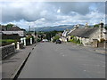
The B914 in Saline
With the Ochils in the background.
Image: © David Purchase
Taken: 30 Aug 2017
0.12 miles
5
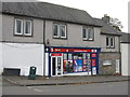
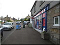
Saline Post Office
In a new location since recorded by Paul McIlroy in 2006 Image In Google Earth imagery of 2009 this was just a general store, and this makeover looks fairly recent.
Image: © M J Richardson
Taken: 8 Oct 2019
0.15 miles
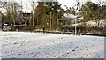
7
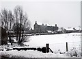
Green (white) space, Saline
A green space off Main Street at the eastern end of the village.
Image: © Richard Webb
Taken: 6 Dec 2011
0.16 miles
8
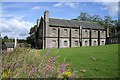
Saline and Blairingone Parish Church
This Church of Scotland building in Main Street was constructed from 1808 – 10.
Image: © Walter Baxter
Taken: 5 Aug 2011
0.18 miles
9
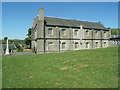
Saline and Blairingone Parish Church
Saline and Blairingone Parish Church was constructed 1808-10 by William Stark.
Image: © Euan Nelson
Taken: 27 May 2012
0.18 miles
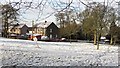
10
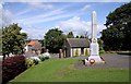
Saline War Memorial
The war memorial is in front of the western end of the parish church. The church session house is in the background by the entrance gates to the church precinct.
Image: © Walter Baxter
Taken: 5 Aug 2011
0.18 miles