IMAGES TAKEN NEAR TO
DUNFERMLINE, KY12 9PB
Introduction
This page details the photographs taken nearby to KY12 9PB by members of the Geograph project.
The Geograph project started in 2005 with the aim of publishing, organising and preserving representative images for every square kilometre of Great Britain, Ireland and the Isle of Man.

There are currently over 7.5m images from over14,400 individuals and you can help contribute to the project by visiting https://www.geograph.org.uk
Image Map
Images are licensed for reuse under creativecommons.org/licenses/by-sa/2.0
Notes
- Clicking on the map will re-center to the selected point.
- The higher the marker number, the further away the image location is from the centre of the postcode.
Image Listing (4 Images Found)
Images are licensed for reuse under creativecommons.org/licenses/by-sa/2.0
Image
Details
Distance
1
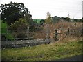
East Camps
View from a bridge that used to carry the railway from Alloa to Dunfermline. The trackbed is now a cycle path.
Image: © Richard Webb
Taken: 15 Oct 2009
0.12 miles
2
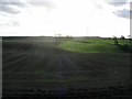
Stubble, Gowkhall.
Stubble in front of a low winter sun. Looking south from Gowkhall towards the Dean Plantation.
Image: © Richard Webb
Taken: 9 Nov 2005
0.20 miles
3
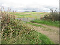
Stubble, East Cairns
Access from the railway trackbed.
Image: © Richard Webb
Taken: 19 Sep 2022
0.20 miles
4
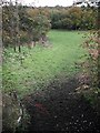
Underpass for cattle
View of a field and Dean Plantation from the trackbed of the Stirling and Dunfermline Railway.
Image: © Richard Webb
Taken: 15 Oct 2009
0.22 miles