IMAGES TAKEN NEAR TO
DUNFERMLINE, KY12 9LS
Introduction
This page details the photographs taken nearby to KY12 9LS by members of the Geograph project.
The Geograph project started in 2005 with the aim of publishing, organising and preserving representative images for every square kilometre of Great Britain, Ireland and the Isle of Man.

There are currently over 7.5m images from over14,400 individuals and you can help contribute to the project by visiting https://www.geograph.org.uk
Image Map
Images are licensed for reuse under creativecommons.org/licenses/by-sa/2.0
Notes
- Clicking on the map will re-center to the selected point.
- The higher the marker number, the further away the image location is from the centre of the postcode.
Image Listing (7 Images Found)
Images are licensed for reuse under creativecommons.org/licenses/by-sa/2.0
Image
Details
Distance
1
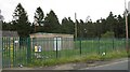
Reservoir, Lynn Farm
Covered reservoir beside the Saline - Kelty Road.
Image: © Richard Webb
Taken: 25 Sep 2008
0.02 miles
2
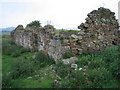
Redcraigs ruined cottage
One of many abandoned buildings in the area.
Image: © Ian Mitchell
Taken: 19 Jun 2005
0.04 miles
3
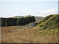
Redcraigs
Ruin near Knock Hill (background).
Image: © Richard Webb
Taken: 7 Jul 2020
0.08 miles
4
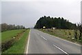
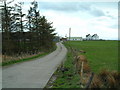
B914, Linn
Kelty - Saline road running beneath Saline and Knock Hill.
Image: © Richard Webb
Taken: 24 Apr 2015
0.09 miles
5
A823, Roscobie
Crieff to Dunfermline road just north of a crossroads with Saline Hill in the background.
Image: © Richard Webb
Taken: 31 Oct 2008
0.17 miles
6
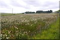
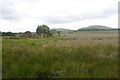
Wetland and meadowsweet, Redcraigs
Between the B914 and A823.
Image: © Richard Webb
Taken: 7 Jul 2020
0.21 miles
7
Lynn Farm
Road to the farm, located south of the Roscobie Hills
Image: © James Allan
Taken: 3 May 2006
0.25 miles