IMAGES TAKEN NEAR TO
Carnock, DUNFERMLINE, KY12 9JJ
Introduction
This page details the photographs taken nearby to KY12 9JJ by members of the Geograph project.
The Geograph project started in 2005 with the aim of publishing, organising and preserving representative images for every square kilometre of Great Britain, Ireland and the Isle of Man.

There are currently over 7.5m images from over14,400 individuals and you can help contribute to the project by visiting https://www.geograph.org.uk
Image Map
Images are licensed for reuse under creativecommons.org/licenses/by-sa/2.0
Notes
- Clicking on the map will re-center to the selected point.
- The higher the marker number, the further away the image location is from the centre of the postcode.
Image Listing (2 Images Found)
Images are licensed for reuse under creativecommons.org/licenses/by-sa/2.0
Image
Details
Distance
1
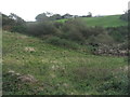
Scrub in the valley of the Carnock Burn
On the eastern outskirts of Oakley.
Image: © M J Richardson
Taken: 8 Oct 2019
0.22 miles
2
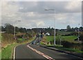
Carnock from Oakley.
Looking east along the A907 from the edge of Oakley towards Carnock.
Image: © Richard Webb
Taken: 9 Nov 2005
0.22 miles