IMAGES TAKEN NEAR TO
Cowstrandburn, DUNFERMLINE, KY12 9HP
Introduction
This page details the photographs taken nearby to KY12 9HP by members of the Geograph project.
The Geograph project started in 2005 with the aim of publishing, organising and preserving representative images for every square kilometre of Great Britain, Ireland and the Isle of Man.

There are currently over 7.5m images from over14,400 individuals and you can help contribute to the project by visiting https://www.geograph.org.uk
Image Map
Images are licensed for reuse under creativecommons.org/licenses/by-sa/2.0
Notes
- Clicking on the map will re-center to the selected point.
- The higher the marker number, the further away the image location is from the centre of the postcode.
Image Listing (5 Images Found)
Images are licensed for reuse under creativecommons.org/licenses/by-sa/2.0
Image
Details
Distance
1
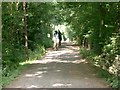
Horses
Horses and riders on the track from Steelend to Cowstrandburn.
Image: © Paul McIlroy
Taken: 9 Aug 2006
0.06 miles
2
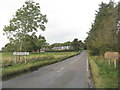
Entering Cowstrandburn from the south
A big name for a small place - there must be story behind the name.
Image: © M J Richardson
Taken: 8 Oct 2019
0.16 miles
3
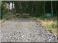
Access Road
Access road to Carnock Moor Forest.
Image: © Paul McIlroy
Taken: 28 Jul 2006
0.17 miles
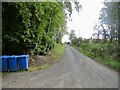
5
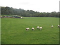
Sheep at Langfauld
Looking northeast to the woodland on the Bandrum escarpment.
Image: © M J Richardson
Taken: 8 Oct 2019
0.23 miles