IMAGES TAKEN NEAR TO
Reid Place, DUNFERMLINE, KY12 9FL
Introduction
This page details the photographs taken nearby to Reid Place, KY12 9FL by members of the Geograph project.
The Geograph project started in 2005 with the aim of publishing, organising and preserving representative images for every square kilometre of Great Britain, Ireland and the Isle of Man.

There are currently over 7.5m images from over14,400 individuals and you can help contribute to the project by visiting https://www.geograph.org.uk
Image Map
Images are licensed for reuse under creativecommons.org/licenses/by-sa/2.0
Notes
- Clicking on the map will re-center to the selected point.
- The higher the marker number, the further away the image location is from the centre of the postcode.
Image Listing (2 Images Found)
Images are licensed for reuse under creativecommons.org/licenses/by-sa/2.0
Image
Details
Distance
1
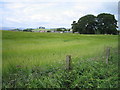
Barley growing on the outskirts of Dunfermline
Image: © Ian Mitchell
Taken: 3 Jul 2005
0.22 miles
2
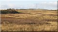
Uncultivated land, Wellwood
An area of land probably awaiting development, It also appears to have been quarried in the past. Maps dated 1903 show this as farmland.
Image: © Richard Webb
Taken: 31 Oct 2008
0.24 miles