IMAGES TAKEN NEAR TO
Woodhill Grove, DUNFERMLINE, KY12 8YG
Introduction
This page details the photographs taken nearby to Woodhill Grove, KY12 8YG by members of the Geograph project.
The Geograph project started in 2005 with the aim of publishing, organising and preserving representative images for every square kilometre of Great Britain, Ireland and the Isle of Man.

There are currently over 7.5m images from over14,400 individuals and you can help contribute to the project by visiting https://www.geograph.org.uk
Image Map
Images are licensed for reuse under creativecommons.org/licenses/by-sa/2.0
Notes
- Clicking on the map will re-center to the selected point.
- The higher the marker number, the further away the image location is from the centre of the postcode.
Image Listing (5 Images Found)
Images are licensed for reuse under creativecommons.org/licenses/by-sa/2.0
Image
Details
Distance
1
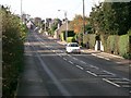
Main Street Crossford.
Looking westwards.
Image: © Paul McIlroy
Taken: 9 Nov 2005
0.15 miles
2
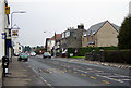
Main Street, Crossford, looking west
Main Street is the A994 which passes through the middle of Crossford. The Pitfirrane Arms can be seen on the left, and the traffic lights at the junction with Waggon Road can be seen in the distance. Most of the recent snow (March 2006) had melted, but some remaining snow can be seen in the gutter on the far side of the road.
Image: © Euchiasmus
Taken: 15 Mar 2006
0.19 miles
3
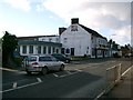
Pitfirrane Arms Hotel
Situated on Main Street opposite The Village Hall.
Image: © Paul McIlroy
Taken: 9 Nov 2005
0.22 miles
5
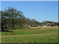
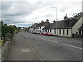
Crossford.
The eastern part of Crossford, seen across farmland from the road to Limekilns. Looking NE.
Image: © Richard Webb
Taken: 9 Nov 2005
0.24 miles