IMAGES TAKEN NEAR TO
Katrine Drive, DUNFERMLINE, KY12 8XR
Introduction
This page details the photographs taken nearby to Katrine Drive, KY12 8XR by members of the Geograph project.
The Geograph project started in 2005 with the aim of publishing, organising and preserving representative images for every square kilometre of Great Britain, Ireland and the Isle of Man.

There are currently over 7.5m images from over14,400 individuals and you can help contribute to the project by visiting https://www.geograph.org.uk
Image Map
Images are licensed for reuse under creativecommons.org/licenses/by-sa/2.0
Notes
- Clicking on the map will re-center to the selected point.
- The higher the marker number, the further away the image location is from the centre of the postcode.
Image Listing (8 Images Found)
Images are licensed for reuse under creativecommons.org/licenses/by-sa/2.0
Image
Details
Distance
1
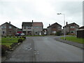
Junction of Hunt Place and Katrine Drive
Image: © Rod Allday
Taken: 26 Apr 2019
0.02 miles
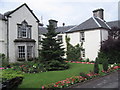
2
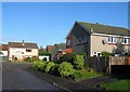
Residential area, Crossford
Crossford, like most villages in the area has grown a bit. This is part of a large housing estate built on what was once the grounds of Keavil House, now a hotel.
Image: © Richard Webb
Taken: 9 Nov 2005
0.04 miles
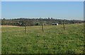
4
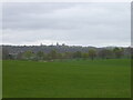
Field on the east side of Waggon Road
Looking towards Dunfermline.
Image: © Rod Allday
Taken: 26 Apr 2019
0.11 miles
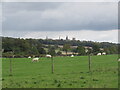
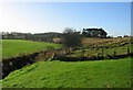
5
Dunfermline from Crossford.
The skyline of Dunfermline, it does not sprawl in this direction. Farmland east of Crossford.
Image: © Richard Webb
Taken: 9 Nov 2005
0.17 miles
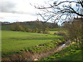
8
Crossford Burn.
Looking SW along the Crossford Burn in the direction of Pitliver. A mix of arable land and parkland. Taken from the edge of Crossford village.
Image: © Richard Webb
Taken: 9 Nov 2005
0.23 miles