IMAGES TAKEN NEAR TO
Garden Place, DUNFERMLINE, KY12 8XA
Introduction
This page details the photographs taken nearby to Garden Place, KY12 8XA by members of the Geograph project.
The Geograph project started in 2005 with the aim of publishing, organising and preserving representative images for every square kilometre of Great Britain, Ireland and the Isle of Man.

There are currently over 7.5m images from over14,400 individuals and you can help contribute to the project by visiting https://www.geograph.org.uk
Image Map
Images are licensed for reuse under creativecommons.org/licenses/by-sa/2.0
Notes
- Clicking on the map will re-center to the selected point.
- The higher the marker number, the further away the image location is from the centre of the postcode.
Image Listing (6 Images Found)
Images are licensed for reuse under creativecommons.org/licenses/by-sa/2.0
Image
Details
Distance
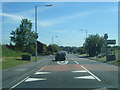
1
Cairneyhill
The centre of the village with a garage/bicycle repair man prominently advertised.
Image: © Richard Webb
Taken: 9 Nov 2005
0.13 miles
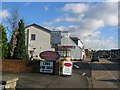
2
Cairneyhill
Residential area to the north of the village. Houses in Rose Gardens overlooking a green area.
Image: © Richard Webb
Taken: 9 Nov 2005
0.15 miles
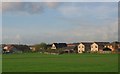
3
Cairneyhill Primary and Community School
Looking west from Pitdinnie Road.
Image: © M J Richardson
Taken: 18 Nov 2016
0.15 miles
4
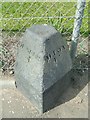
Old Milestone by the A994, Main Street, Cairneyhill
F type by the A994, in parish of Carnock (Fife District), Cairneyhill, Main Street, on pavement in front of wire fence, North side of road.
Inscription reads:-
: DUNFERM / 3 : : ALLOA / 13 :
Surveyed
Milestone Society National ID: FF_DFAO03
Image: © Milestone Society
Taken: Unknown
0.18 miles
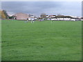
5
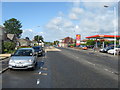
The village centre at Cairneyhill in Fife
Image: © James Denham
Taken: 28 May 2011
0.21 miles