IMAGES TAKEN NEAR TO
Ochilview Drive, DUNFERMLINE, KY12 8UD
Introduction
This page details the photographs taken nearby to Ochilview Drive, KY12 8UD by members of the Geograph project.
The Geograph project started in 2005 with the aim of publishing, organising and preserving representative images for every square kilometre of Great Britain, Ireland and the Isle of Man.

There are currently over 7.5m images from over14,400 individuals and you can help contribute to the project by visiting https://www.geograph.org.uk
Image Map
Images are licensed for reuse under creativecommons.org/licenses/by-sa/2.0
Notes
- Clicking on the map will re-center to the selected point.
- The higher the marker number, the further away the image location is from the centre of the postcode.
Image Listing (8 Images Found)
Images are licensed for reuse under creativecommons.org/licenses/by-sa/2.0
Image
Details
Distance
1
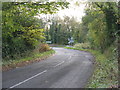
Road junction near Valleyfield
The road from Oakley joins the A985.
Image: © M J Richardson
Taken: 25 Oct 2016
0.11 miles
2
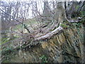
It seemed like a good spot at the time
Tree next to path in Valleyfield Woodland Park
Image: © Thomas Stenhouse
Taken: 25 Mar 2008
0.16 miles
3
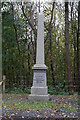
To commemorate Valleyfield Colliery 1908-1978
Image: © Ian S
Taken: 23 Oct 2014
0.19 miles
5
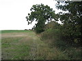
Field margin near Valleyfield
Hedge separating stubble and grass from the road up Clinkum Bank.
Image: © M J Richardson
Taken: 25 Oct 2016
0.20 miles
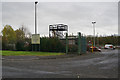
6
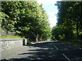
High Valleyfield near Forth View Industrial Estate
Image: © Colin Pyle
Taken: 11 Jun 2015
0.22 miles
7
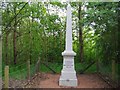
Site of Valleyfield Colliery memorial
First sunk in 1908, and eventually becoming a three pit operation in 1954, Valleyfield was said to produce the best coking and navigational coal in Scotland. Unfortunately, this came at a very high price as Valleyfield witnessed some terrible fatalities in its 70 year history. The worst occurred on 28 October 1939, when 35 men were killed, and 26 injured following an explosion. A memorial to this disaster is located in High Valleyfield.
April 1968 saw the last carts of coal emerge from Valleyfield. Thereafter, operations centred on Kinneil as a tunnel underneath the Forth had linked the two mines. In 1978, Valleyfield finally closed.
Image: © Euan Nelson
Taken: 25 May 2010
0.22 miles
8
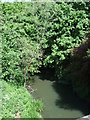
Bluther Burn, High Valleyfield
From the bridge on Main Street.
Image: © JThomas
Taken: 25 May 2017
0.24 miles