IMAGES TAKEN NEAR TO
Greenbank, Main Street, DUNFERMLINE, KY12 8TZ
Introduction
This page details the photographs taken nearby to Greenbank, Main Street, KY12 8TZ by members of the Geograph project.
The Geograph project started in 2005 with the aim of publishing, organising and preserving representative images for every square kilometre of Great Britain, Ireland and the Isle of Man.

There are currently over 7.5m images from over14,400 individuals and you can help contribute to the project by visiting https://www.geograph.org.uk
Image Map
Images are licensed for reuse under creativecommons.org/licenses/by-sa/2.0
Notes
- Clicking on the map will re-center to the selected point.
- The higher the marker number, the further away the image location is from the centre of the postcode.
Image Listing (16 Images Found)
Images are licensed for reuse under creativecommons.org/licenses/by-sa/2.0
Image
Details
Distance
1
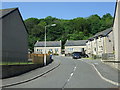
Beech Place, Low Valleyfield
Off Main Street.
Image: © JThomas
Taken: 25 May 2017
0.07 miles
3
National Cycle Network route 76
Cycle path running along the edge of the Valleyfield ash lagoons.
Image: © Richard Webb
Taken: 15 Oct 2009
0.10 miles
5
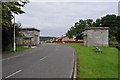
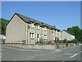
Old Lodge Houses
These lodges marked the entrance to the former estate of Valleyfield House. Valleyfield House itself was demolished in 1918; the lodges are now listed buildings.
Image: © Robert Struthers
Taken: 3 Aug 2012
0.15 miles
6
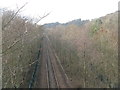
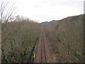
The railway to Longannet
Looking west from the footbridge leading to the Torry Bay Nature Reserve - the path around the ash lagoons.
Image: © M J Richardson
Taken: 12 Feb 2016
0.15 miles
7
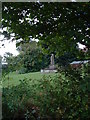
Valleyfield Pit Disaster Memorial
A memorial on the site of Valleyfield Miners Welfare Club. Commemorating the 35 men who died in the Valleyfield Pit disaster on October 28th 1939. The memorial depicts a woman holding a child representing the wives of miners who were lost waiting at the pit head for news of their loved ones. The Inscription reads:-
ERECTED IN MEMORY OF
ALL WHO LOST THEIR LIVES AS A RESULT OF AN IGNITION
OF FIREDAMP AND COALDUST IN THE DIAMOND SECTION OF
VALLEYFIELD PIT ON OCTOBER 28TH 1939 AT ABOUT 4AM
TEARFULLY THEY CAME TO VALLEYFIELD PITHEAD
ON THAT AUTUMN DAY
IN PAINFUL GRIEF TO CLAIM THE DEAD
WITH DEEP RESPECT WE PRAY
ALSO TO THE MEMORY OF
ALL THOSE WHO DIED AS A RESULT OF WORKING IN THE MINE
1908 - 1978
Image: © Craig J Seath
Taken: 13 Aug 2005
0.17 miles
8

Detail of the Valleyfield Pit Disaster Memorial
Detail of the sculpture of the Valleyfield Pit Disaster Memorial representing a wife with her child waiting at the pit head for news of the disaster where 35 men were killed as the result of an underground explosion in 1939.
Image: © Craig J Seath
Taken: 13 Aug 2005
0.17 miles
9
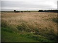
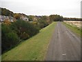
Ash lagoons, Low Valleyfield
The inland part of reclaimed land formed by dumping Longannet ash into the Forth.
Image: © Richard Webb
Taken: 15 Oct 2009
0.17 miles
10
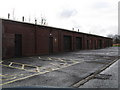
Industrial lock-up units at Low Valleyfield
In the west of Fife.
Image: © James Denham
Taken: 1 Mar 2009
0.18 miles