IMAGES TAKEN NEAR TO
Hilton Road, DUNFERMLINE, KY12 8RG
Introduction
This page details the photographs taken nearby to Hilton Road, KY12 8RG by members of the Geograph project.
The Geograph project started in 2005 with the aim of publishing, organising and preserving representative images for every square kilometre of Great Britain, Ireland and the Isle of Man.

There are currently over 7.5m images from over14,400 individuals and you can help contribute to the project by visiting https://www.geograph.org.uk
Image Map
Images are licensed for reuse under creativecommons.org/licenses/by-sa/2.0
Notes
- Clicking on the map will re-center to the selected point.
- The higher the marker number, the further away the image location is from the centre of the postcode.
Image Listing (10 Images Found)
Images are licensed for reuse under creativecommons.org/licenses/by-sa/2.0
Image
Details
Distance
1
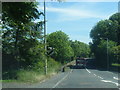
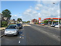
A994 heading east at edge of Cairneyhill
Image: © Colin Pyle
Taken: 11 Jun 2015
0.05 miles
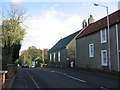
2
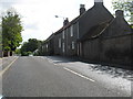
Buildings at the east end of Cairneyhill in Fife
The last of the larger buildings is Cairneyhill Church.
Image: © James Denham
Taken: 28 May 2011
0.05 miles
3
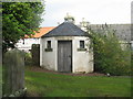
Cairneyhill Watch House
Where watch was kept to prevent grave robbers from stealing corpses. In the graveyard at Cairneyhill. Restored with Lottery funding in 2007.
Image: © M J Richardson
Taken: 24 Sep 2019
0.06 miles
4
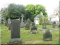
Cairneyhill graveyard
With surprisingly widely spaced memorials, and the watch house.
Image: © M J Richardson
Taken: 24 Sep 2019
0.06 miles
5
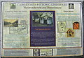
Cairneyhill Historic Graveyard
Information board about the Resurrectionists, a 'profession' that arose from the need for human bodies for study and dissection by trainee medics in the 18thC, at the entrance to Cairneyhill graveyard. There are also some old [17thC] gravestones in the graveyard.
Image: © M J Richardson
Taken: 24 Sep 2019
0.06 miles
6
Cairneyhill Kirk.
East edge of the village with the road passing the church bound for Dunfermline.
Image: © Richard Webb
Taken: 9 Nov 2005
0.09 miles
7
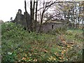
Thimble Hall Ruins
According to the Ordnance Survey Name Book c.1854, "The name originated from the house being built by a Thomas Wilson, a Tailor".
Image: © Robert Struthers
Taken: 25 Oct 2020
0.11 miles
8
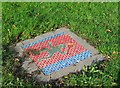
Mosaic, Cairneyhill
Mosaic in the grass verge where Pitdinnie Road meets the main road through Cairniehill.
Image: © Richard Webb
Taken: 9 Nov 2005
0.12 miles
9
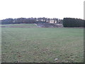
Pasture at Crossford
Looking east to Walk Plantation.
Image: © M J Richardson
Taken: 18 Nov 2016
0.12 miles
10
The village centre at Cairneyhill in Fife
Image: © James Denham
Taken: 28 May 2011
0.25 miles