IMAGES TAKEN NEAR TO
Woodlands Drive, DUNFERMLINE, KY12 8QE
Introduction
This page details the photographs taken nearby to Woodlands Drive, KY12 8QE by members of the Geograph project.
The Geograph project started in 2005 with the aim of publishing, organising and preserving representative images for every square kilometre of Great Britain, Ireland and the Isle of Man.

There are currently over 7.5m images from over14,400 individuals and you can help contribute to the project by visiting https://www.geograph.org.uk
Image Map
Images are licensed for reuse under creativecommons.org/licenses/by-sa/2.0
Notes
- Clicking on the map will re-center to the selected point.
- The higher the marker number, the further away the image location is from the centre of the postcode.
Image Listing (3 Images Found)
Images are licensed for reuse under creativecommons.org/licenses/by-sa/2.0
Image
Details
Distance
1
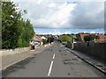
A street scene at the west end of Crossford
In Fife.
Image: © James Denham
Taken: 28 May 2011
0.16 miles
2
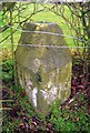
Old Milestone by the A994, Crossford, Dunfermline
F type by the A994, in parish of Dunfermline (Fife District), West end of Crossford, under hedge, North side of road.
Inscription reads:-
: DUNFERMLINE / 2 : : ALLOA / 14 :
Surveyed
Milestone Society National ID: FF_DFAO02
Image: © Milestone Society
Taken: Unknown
0.18 miles
3
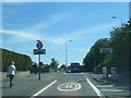
A994 eastbound at Crossford village boundary
Image: © Colin Pyle
Taken: 11 Jun 2015
0.19 miles