IMAGES TAKEN NEAR TO
Main Street, DUNFERMLINE, KY12 8LS
Introduction
This page details the photographs taken nearby to Main Street, KY12 8LS by members of the Geograph project.
The Geograph project started in 2005 with the aim of publishing, organising and preserving representative images for every square kilometre of Great Britain, Ireland and the Isle of Man.

There are currently over 7.5m images from over14,400 individuals and you can help contribute to the project by visiting https://www.geograph.org.uk
Image Map
Images are licensed for reuse under creativecommons.org/licenses/by-sa/2.0
Notes
- Clicking on the map will re-center to the selected point.
- The higher the marker number, the further away the image location is from the centre of the postcode.
Image Listing (43 Images Found)
Images are licensed for reuse under creativecommons.org/licenses/by-sa/2.0
Image
Details
Distance
1
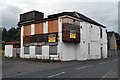
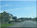
The Bay - Closed
The Bay Hotel, been derelict for a few years now.
Image: © Robert Struthers
Taken: 3 Aug 2012
0.01 miles
2
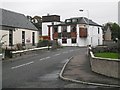
The Bay
Pub in Torryburn. The name is also presented in neon lights.
Image: © Richard Webb
Taken: 15 Oct 2009
0.03 miles
4
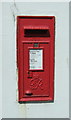
George VI postbox on Main Street, Torryburn
Postbox No. KY12 161.
Image: © JThomas
Taken: 25 May 2017
0.07 miles
5
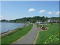
Playground apparatus, The Ness
Grangemouth in the background across the Forth.
Image: © Richard Webb
Taken: 15 Oct 2009
0.08 miles
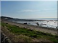
6

'The Ness' - Torryburn
The Fife Coastal Path sweeps round Torry Bay here.
Image: © Frank Smith
Taken: 19 Apr 2013
0.08 miles
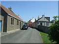
9
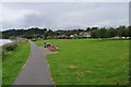
Torryburn Park
Small park and playground on the shore at Torryburn.
Image: © Robert Struthers
Taken: 3 Aug 2012
0.09 miles
10
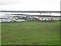
Torryburn shore
Looking towards Crombie Point.
Image: © James Allan
Taken: 28 Mar 2012
0.09 miles