IMAGES TAKEN NEAR TO
Catherines Wynd, DUNFERMLINE, KY12 8EU
Introduction
This page details the photographs taken nearby to Catherines Wynd, KY12 8EU by members of the Geograph project.
The Geograph project started in 2005 with the aim of publishing, organising and preserving representative images for every square kilometre of Great Britain, Ireland and the Isle of Man.

There are currently over 7.5m images from over14,400 individuals and you can help contribute to the project by visiting https://www.geograph.org.uk
Image Map
Images are licensed for reuse under creativecommons.org/licenses/by-sa/2.0
Notes
- Clicking on the map will re-center to the selected point.
- The higher the marker number, the further away the image location is from the centre of the postcode.
Image Listing (6 Images Found)
Images are licensed for reuse under creativecommons.org/licenses/by-sa/2.0
Image
Details
Distance
1
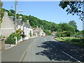
Footpath near Valleyfield
This path was originally the main road into High Valleyfield before the by-pass was built.
Image: © Robert Struthers
Taken: 3 Aug 2012
0.14 miles
2
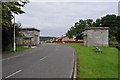
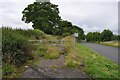
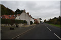
Old Lodge Houses
These lodges marked the entrance to the former estate of Valleyfield House. Valleyfield House itself was demolished in 1918; the lodges are now listed buildings.
Image: © Robert Struthers
Taken: 3 Aug 2012
0.18 miles
5
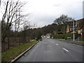
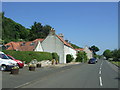
The coastal road through Low Valleyfield in Fife
Image: © James Denham
Taken: 1 Mar 2009
0.20 miles