IMAGES TAKEN NEAR TO
Culross, DUNFERMLINE, KY12 8EN
Introduction
This page details the photographs taken nearby to KY12 8EN by members of the Geograph project.
The Geograph project started in 2005 with the aim of publishing, organising and preserving representative images for every square kilometre of Great Britain, Ireland and the Isle of Man.

There are currently over 7.5m images from over14,400 individuals and you can help contribute to the project by visiting https://www.geograph.org.uk
Image Map
Images are licensed for reuse under creativecommons.org/licenses/by-sa/2.0
Notes
- Clicking on the map will re-center to the selected point.
- The higher the marker number, the further away the image location is from the centre of the postcode.
Image Listing (7 Images Found)
Images are licensed for reuse under creativecommons.org/licenses/by-sa/2.0
Image
Details
Distance
1
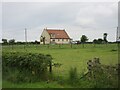
Blairsgreen House
Looking south-west to Blairsgreen House near Gallowridge Farm.
Image: © Scott Cormie
Taken: 11 Jul 2024
0.01 miles
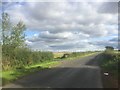
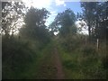
3
Minor road
This unclassified road runs northwards from Culross to the Dunfermline- Stirling road (A907). This is a view northwards at Gallowridge.
Image: © Paul McIlroy
Taken: 26 Nov 2006
0.08 miles
4
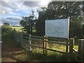
Map board with path information, Gallowridge
Image: © Richard Webb
Taken: 28 Aug 2020
0.08 miles
5
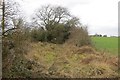
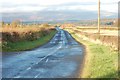
Once a track
A road shown on old maps has gone now. I once followed it as far as the trig point from Devilla Forest.
--
2020
The path has been reopened, is of high quality and it is easy to access Devilla from the road to the east now.
Image: © Richard Webb
Taken: 6 Mar 2015
0.10 miles
7
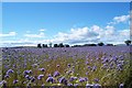
Phacelia Sacrificial Crop
Adding a splash of colour to the countryside, this plant is grown as a 'green manure' crop to increase soil fertility.
Image: © James T M Towill
Taken: 29 Jul 2007
0.24 miles