IMAGES TAKEN NEAR TO
Colton Terrace, William Street, DUNFERMLINE, KY12 8DU
Introduction
This page details the photographs taken nearby to Colton Terrace, William Street, KY12 8DU by members of the Geograph project.
The Geograph project started in 2005 with the aim of publishing, organising and preserving representative images for every square kilometre of Great Britain, Ireland and the Isle of Man.

There are currently over 7.5m images from over14,400 individuals and you can help contribute to the project by visiting https://www.geograph.org.uk
Image Map
Images are licensed for reuse under creativecommons.org/licenses/by-sa/2.0
Notes
- Clicking on the map will re-center to the selected point.
- The higher the marker number, the further away the image location is from the centre of the postcode.
Image Listing (11 Images Found)
Images are licensed for reuse under creativecommons.org/licenses/by-sa/2.0
Image
Details
Distance
1
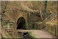
Tunnel
The Baldridge Burn flows through this tunnel under the former Dunfermline to Stirling railway line. The tunnel is also part of a pedestrian walkway.
Image: © Paul McIlroy
Taken: 9 Apr 2007
0.11 miles
2

William Street
This is the part of William Street in Dunfermline, where the Baldridge Burn runs beneath the road. The stone structure on the pavement is all that remains of a railway bridge which carried the Dunfermline to Stirling line. The bridge was demolished in 1997, the remaining section is part of the road bridge so it had to be retained.
Image: © Paul McIlroy
Taken: 9 Apr 2007
0.12 miles
3
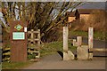
Cycleway
This is the start of the Dunfermline to Alloa section of the West Fife cycle network.
Image: © Paul McIlroy
Taken: 9 Apr 2007
0.13 miles
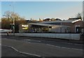
4
Car park, West Fife Cycleway
Car park and recycling bins at the Dunfermline end of the West Fife Cycleway which uses a disused railway to get to Clackmannan.
Image: © Richard Webb
Taken: 15 Oct 2009
0.13 miles
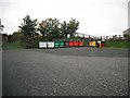
6
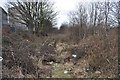
Long Gone Railway
The trackbed of the former Stirling and Dunfermline Railway, closed in the late 1960s.
Image: © Robert Struthers
Taken: 6 Mar 2010
0.17 miles
7
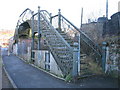
Phoenix Lane, Dunfermline Footbridge
The footbridge is a listed 'building' over a long disused railway.
Image: © Ian Mitchell
Taken: 28 Dec 2003
0.21 miles
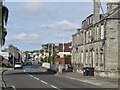
8
Magnet Trade, Dunfermline
This kitchen suppliers and outfitters can be found in Baldridgeburn (B9155), Dunfermline.
Image: © Bill Kasman
Taken: 5 Nov 2019
0.24 miles
10
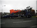
Loading a transporter
With a smell of clutch, the orange van takes off up the ramp. The following vehicle was loaded by winch. Seen across Golfdrum Street.
Image: © Richard Webb
Taken: 15 Oct 2009
0.24 miles