IMAGES TAKEN NEAR TO
School Street, DUNFERMLINE, KY12 8BZ
Introduction
This page details the photographs taken nearby to School Street, KY12 8BZ by members of the Geograph project.
The Geograph project started in 2005 with the aim of publishing, organising and preserving representative images for every square kilometre of Great Britain, Ireland and the Isle of Man.

There are currently over 7.5m images from over14,400 individuals and you can help contribute to the project by visiting https://www.geograph.org.uk
Image Map
Images are licensed for reuse under creativecommons.org/licenses/by-sa/2.0
Notes
- Clicking on the map will re-center to the selected point.
- The higher the marker number, the further away the image location is from the centre of the postcode.
Image Listing (21 Images Found)
Images are licensed for reuse under creativecommons.org/licenses/by-sa/2.0
Image
Details
Distance
1
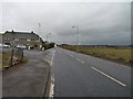
Main road in Crombie
The road sign points to 'DM Crombie' which stands for 'Defence Munitions Centre, Crombie' a large cache of naval armaments formerly known as Royal Naval Armament Depot (RNAD) Crombie. This is associated with the Naval dockyard of Rosyth, close enough to make the transfer of armaments onto warships convenient, yet far enough away to make any explosion of the munitions depot unlikely to cause too much dockyard or warship damage.
Image: © James Allan
Taken: 20 Feb 2012
0.01 miles
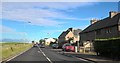
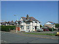
5

Crombie.
Row of houses in Crombie with a good view over the Forth.
Image: © Richard Webb
Taken: 9 Nov 2005
0.19 miles
6
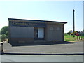
Former Crombie Store
Showing position of Postbox No. KY12 103.
See Image] for postbox.
Image: © JThomas
Taken: 25 May 2017
0.20 miles
7
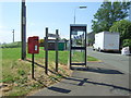
Elizabethan postbox and telephone box, Crombie
Image: © JThomas
Taken: 25 May 2017
0.20 miles
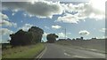
8

A985
Very busy road along the north of the Firth of Forth, seen from Crombie, with the Ochil Hills in the distance.
Image: © Richard Webb
Taken: 9 Nov 2005
0.20 miles
10
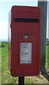
Close up, Elizabethan postbox, Crombie
Postbox No. KY12 103.
See Image] for wider view.
Image: © JThomas
Taken: 25 May 2017
0.21 miles