IMAGES TAKEN NEAR TO
Canon Lynch Court, DUNFERMLINE, KY12 8AX
Introduction
This page details the photographs taken nearby to Canon Lynch Court, KY12 8AX by members of the Geograph project.
The Geograph project started in 2005 with the aim of publishing, organising and preserving representative images for every square kilometre of Great Britain, Ireland and the Isle of Man.

There are currently over 7.5m images from over14,400 individuals and you can help contribute to the project by visiting https://www.geograph.org.uk
Image Map
Images are licensed for reuse under creativecommons.org/licenses/by-sa/2.0
Notes
- Clicking on the map will re-center to the selected point.
- The higher the marker number, the further away the image location is from the centre of the postcode.
Image Listing (191 Images Found)
Images are licensed for reuse under creativecommons.org/licenses/by-sa/2.0
Image
Details
Distance
3
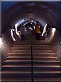
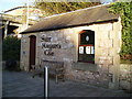
St. Margaret's Cave
Tunnel steps leading out of St. Margaret's Cave.
Reverse view: http://www.geograph.org.uk/photo/225037
Image: © Simon Johnston
Taken: 7 Sep 2008
0.07 miles
5
St. Margaret's Cave
This small building houses a small museum and entrance to the cave. The cave is closed during the winter months.
Image: © Douglas Nelson
Taken: 3 Jan 2015
0.09 miles
6
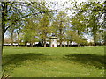
Doo'cot, Pittencrieff Park, Dunfermline
Image: © Douglas Nelson
Taken: 11 May 2015
0.09 miles
7
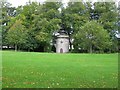
Old Dovecot, Pittencrieff Park, Dunfermline
The Old Dovecot is located to the right of the main drive leading into the park from the Louise Carnegie Gates. The sandstone dovecot dates from the late 18th or early 19th century. It is a Category B listed building. https://www.britishlistedbuildings.co.uk/200362440-dunfermline-pittencrieff-park-old-dovecot-dunfermline#.WdPuejGWw5s
Image: © G Laird
Taken: 3 Oct 2017
0.09 miles
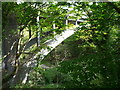
8
The Glen Bridge
The Glen Bridge was built in 1932 to cross the Tower Burn and link Carnegie Drive to Pittencrieff Street. This view is towards Pittencrieff Street.
Image: © Paul McIlroy
Taken: 15 Apr 2007
0.10 miles
9
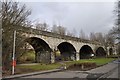
Old Railway Viaduct
This viaduct carried the Dunfermline and Stirling Railway. The line closed in the late 1960s.
Image: © Robert Struthers
Taken: 6 Mar 2010
0.10 miles
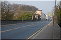
10
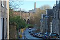
Buffie's Brae
Buffie's Brae used to be a through road but in the 1970s the eastern end was closed up because too many drivers were using this narrow street as a shortcut.The railway viaduct used to carry The Dunfermline to Stirling Line across The Tower Burn.The building in the top right is Merchison House, social security and inland revenue etc. The chimney belongs to an empty factory in Pilmuir Street.
Image: © Paul McIlroy
Taken: 2 Jan 2007
0.10 miles