IMAGES TAKEN NEAR TO
Orwell Place, DUNFERMLINE, KY12 7XP
Introduction
This page details the photographs taken nearby to Orwell Place, KY12 7XP by members of the Geograph project.
The Geograph project started in 2005 with the aim of publishing, organising and preserving representative images for every square kilometre of Great Britain, Ireland and the Isle of Man.

There are currently over 7.5m images from over14,400 individuals and you can help contribute to the project by visiting https://www.geograph.org.uk
Image Map
Images are licensed for reuse under creativecommons.org/licenses/by-sa/2.0
Notes
- Clicking on the map will re-center to the selected point.
- The higher the marker number, the further away the image location is from the centre of the postcode.
Image Listing (15 Images Found)
Images are licensed for reuse under creativecommons.org/licenses/by-sa/2.0
Image
Details
Distance
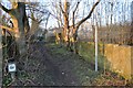
1
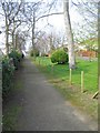
Footpath on Garvock Hill
This footpath runs alongside St John's Drive at the east end of Garvock Hill. It follows the line of an old road which ran from Transy to Brucefield.
Image: © Robert Struthers
Taken: 23 Mar 2012
0.05 miles
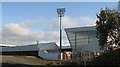
2
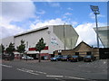
East End Park
Home of Dunfermline Athletic Football Club
Image: © Ian Mitchell
Taken: 3 Jul 2005
0.16 miles
4
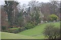
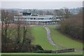
Barnum House
Victorian mansion on the eastern side of Dunfermline Public Park.
Image: © Paul McIlroy
Taken: 25 Feb 2007
0.19 miles
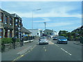
5
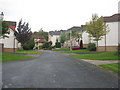
Tolmount Drive, Dunfermline
A housing estate in the Garvock Hill area of the town.
Image: © M J Richardson
Taken: 24 Sep 2019
0.19 miles
6
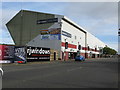
East End Park, Dunfermline
Situated on Halbeath Road (A907), East End Park is the home Dunfermline Athletic Football Club, which at the time of submission of this photograph is a Scottish Championship (2nd tier of football in Scotland) club.
Image: © G Laird
Taken: 3 Oct 2017
0.19 miles
8
School
St Margaret's Primary School viewed from the neighbouring Public Park.
Image: © Paul McIlroy
Taken: 25 Feb 2007
0.21 miles
9
Dunfermline Footpath
This footpath connects Woodmill Road to Tolmount Drive, crossing the Fife Circle railway line.
Image: © Robert Struthers
Taken: 6 Feb 2015
0.22 miles
10
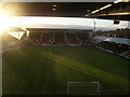
East End Park
A view from behind the northwestern corner flag. Home of Dunfermline Athletic.
Image: © Richard Webb
Taken: 31 Oct 2008
0.22 miles