IMAGES TAKEN NEAR TO
Old Kirk Road, DUNFERMLINE, KY12 7SS
Introduction
This page details the photographs taken nearby to Old Kirk Road, KY12 7SS by members of the Geograph project.
The Geograph project started in 2005 with the aim of publishing, organising and preserving representative images for every square kilometre of Great Britain, Ireland and the Isle of Man.

There are currently over 7.5m images from over14,400 individuals and you can help contribute to the project by visiting https://www.geograph.org.uk
Image Map
Images are licensed for reuse under creativecommons.org/licenses/by-sa/2.0
Notes
- Clicking on the map will re-center to the selected point.
- The higher the marker number, the further away the image location is from the centre of the postcode.
Image Listing (3 Images Found)
Images are licensed for reuse under creativecommons.org/licenses/by-sa/2.0
Image
Details
Distance
1
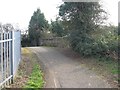
Old Railway Bridge
This bridge dates from the mid-to-late 19th century when the North British Railway opened the line from Inverkeithing to Dunfermline.
Image: © Robert Struthers
Taken: 23 Mar 2012
0.18 miles
2
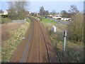
Railway Lines
Looking east along the railway tracks of the Fife Circle. Next station in this direction is Dunfermline Queen Margaret. The road on the right is Garvock Bank.
Image: © Robert Struthers
Taken: 23 Mar 2012
0.19 miles
3
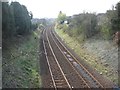
Curved Perspective
Looking west along the Fife Circle line. Next stop, Dunfermline Town.
Image: © Robert Struthers
Taken: 23 Mar 2012
0.19 miles