IMAGES TAKEN NEAR TO
Elgin Street, DUNFERMLINE, KY12 7SA
Introduction
This page details the photographs taken nearby to Elgin Street, KY12 7SA by members of the Geograph project.
The Geograph project started in 2005 with the aim of publishing, organising and preserving representative images for every square kilometre of Great Britain, Ireland and the Isle of Man.

There are currently over 7.5m images from over14,400 individuals and you can help contribute to the project by visiting https://www.geograph.org.uk
Image Map
Images are licensed for reuse under creativecommons.org/licenses/by-sa/2.0
Notes
- Clicking on the map will re-center to the selected point.
- The higher the marker number, the further away the image location is from the centre of the postcode.
Image Listing (107 Images Found)
Images are licensed for reuse under creativecommons.org/licenses/by-sa/2.0
Image
Details
Distance
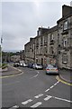
2
Lyne House
Public house on the crossroads of Grange Road, Nethertown Broad Street and Forth Street. Taken while waiting for the lights on Grange Road.
Image: © Richard Webb
Taken: 15 Oct 2009
0.07 miles
3
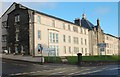
New City House
This local council building stands on the site that was occupied for 99 years (1894-1993) by Dunfermline and West Fife Hospital. Some of the original building, which was called The New Cottage Hospital has been retained, the gable end nearest the camera and the middle section of the facade.
Image: © Paul McIlroy
Taken: 2 Jan 2007
0.07 miles
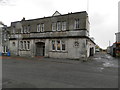
4
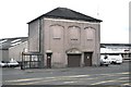
Mystery Building
This rather drab building on Nethertown Broad Street is probably something to do with public utilities.
Image: © Robert Struthers
Taken: 25 Jun 2011
0.08 miles
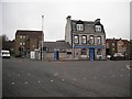
5
Reid Street, looking north
Reid Street at its junction with Nethertown Broad Street.
Image: © Robert Struthers
Taken: 25 Jun 2011
0.10 miles
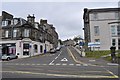
6

Nethertown Broad Street - Dunfermline
Image: © Anthony Parkes
Taken: 22 Aug 2016
0.10 miles
7
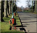
Pittencrieff Park
The start of main driveway at the south end of the park.
Image: © Paul McIlroy
Taken: 27 Mar 2008
0.10 miles
8
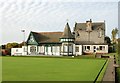
Dunfermline Bowling Club Pavilion
Dunfermline Bowling Club was formed in 1852,the pavilion was built in 1895 at a cost of three hundred pounds,it is now a grade B listed building.
Image: © Paul McIlroy
Taken: 29 Oct 2006
0.10 miles
9

Old Dunfermline High School
This building which is situated off Priory Lane was Dunfermline High School from when it was built,in 1886,until 1939 when pupils and staff moved to a new building in St Leonard's Place. The building which is category B listed was used for various educational purposes until it was converted into flats in 1993. Image
Image: © Paul McIlroy
Taken: 31 Oct 2006
0.10 miles