IMAGES TAKEN NEAR TO
St. Margaret Wynd, DUNFERMLINE, KY12 0UT
Introduction
This page details the photographs taken nearby to St. Margaret Wynd, KY12 0UT by members of the Geograph project.
The Geograph project started in 2005 with the aim of publishing, organising and preserving representative images for every square kilometre of Great Britain, Ireland and the Isle of Man.

There are currently over 7.5m images from over14,400 individuals and you can help contribute to the project by visiting https://www.geograph.org.uk
Image Map
Images are licensed for reuse under creativecommons.org/licenses/by-sa/2.0
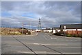
Notes
- Clicking on the map will re-center to the selected point.
- The higher the marker number, the further away the image location is from the centre of the postcode.
Image Listing (53 Images Found)
Images are licensed for reuse under creativecommons.org/licenses/by-sa/2.0
Image
Details
Distance
1
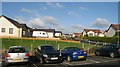
Queen Margaret Fauld (1)
Queen Margaret Fauld at the junction with Whitefield Road. Accesses a small housing estate and loops back round to rejoin Whitefield Road further down.
Image: © Robert Struthers
Taken: 12 Mar 2010
0.06 miles
3
Queen Margaret Fauld (2)
The other end of Queen Margaret Fauld (see also Image) at the junction with Whitefield Road.
Image: © Robert Struthers
Taken: 12 Mar 2010
0.07 miles
4
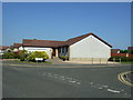
Queen Margaret Hospital, Dunfermline
Queen Margaret Hospital viewed from the car park.
Image: © edward mcmaihin
Taken: 5 Feb 2010
0.10 miles
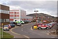
5
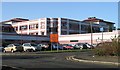
Queen Margaret Hospital
The main hospital serving the Dunfermline area.
Image: © Richard Webb
Taken: 31 Oct 2008
0.10 miles
6
Queen Margaret Hospital
General hospital built on a greenfield site on the edge of town.
Image: © Ian Mitchell
Taken: 3 Jul 2005
0.11 miles
7
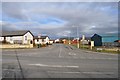
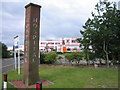
Hill of St. Margaret
New housing estate and the St. Margaret station carpark.
Image: © Richard Webb
Taken: 31 Oct 2008
0.11 miles
8
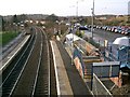
Queen Margaret Station.
The other Dunfermline railway station built to serve the nearby hospital.
Image: © Paul McIlroy
Taken: 15 Dec 2005
0.15 miles
9

Junction of Robertson and Whitefield Roads
Image: © Robert Struthers
Taken: 12 Mar 2010
0.15 miles
10
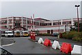
Queen Margaret Hospital
This is the main hospital for the Dunfermline area, it was built in the early 1990s as a replacement for the Dunfermline and West Fife Hospital which had served the town for almost 100 years. This view is towards Hill of Beath.
Image: © Paul McIlroy
Taken: 20 Mar 2007
0.15 miles