IMAGES TAKEN NEAR TO
Player Drive, DUNFERMLINE, KY12 0UR
Introduction
This page details the photographs taken nearby to Player Drive, KY12 0UR by members of the Geograph project.
The Geograph project started in 2005 with the aim of publishing, organising and preserving representative images for every square kilometre of Great Britain, Ireland and the Isle of Man.

There are currently over 7.5m images from over14,400 individuals and you can help contribute to the project by visiting https://www.geograph.org.uk
Image Map
Images are licensed for reuse under creativecommons.org/licenses/by-sa/2.0
Notes
- Clicking on the map will re-center to the selected point.
- The higher the marker number, the further away the image location is from the centre of the postcode.
Image Listing (74 Images Found)
Images are licensed for reuse under creativecommons.org/licenses/by-sa/2.0
Image
Details
Distance
1
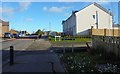
Russell Avenue, Kingseat
The B912 Main Street passes one of two ways into Taylor Wimpey's new housing development at Russell Avenue.
Image: © Bill Kasman
Taken: 5 Nov 2019
0.05 miles
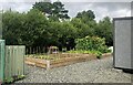
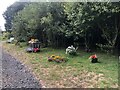
2
Kingseat Community Garden
Vegetable planters.
Image: © Bill Kasman
Taken: 29 Jul 2021
0.05 miles
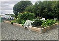
3
Kingseat Community Garden
Inside the garden.
Image: © Bill Kasman
Taken: 29 Jul 2021
0.05 miles
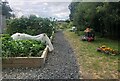
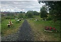
4
Kingseat Community Garden
Vegetable plots.
Image: © Bill Kasman
Taken: 29 Jul 2021
0.05 miles
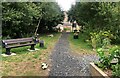
5
Kingseat Community Garden
Inside the garden.
Image: © Bill Kasman
Taken: 29 Jul 2021
0.05 miles
6

Kingseat Community Garden
The poly tunnel.
Image: © Bill Kasman
Taken: 29 Jul 2021
0.05 miles
7

Kingseat Community Garden
A display of petunia.
Image: © Bill Kasman
Taken: 29 Jul 2021
0.05 miles
8
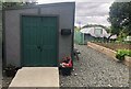
Kingseat Community Garden
Storage shed.
Image: © Bill Kasman
Taken: 29 Jul 2021
0.05 miles
9
Kingseat Community Garden
Inside the garden.
Image: © Bill Kasman
Taken: 29 Jul 2021
0.05 miles
10
Kingseat Community Garden
Inside the garden.
Image: © Bill Kasman
Taken: 29 Jul 2021
0.05 miles