IMAGES TAKEN NEAR TO
Queen Margaret Fauld, DUNFERMLINE, KY12 0RL
Introduction
This page details the photographs taken nearby to Queen Margaret Fauld, KY12 0RL by members of the Geograph project.
The Geograph project started in 2005 with the aim of publishing, organising and preserving representative images for every square kilometre of Great Britain, Ireland and the Isle of Man.

There are currently over 7.5m images from over14,400 individuals and you can help contribute to the project by visiting https://www.geograph.org.uk
Image Map
Images are licensed for reuse under creativecommons.org/licenses/by-sa/2.0
Notes
- Clicking on the map will re-center to the selected point.
- The higher the marker number, the further away the image location is from the centre of the postcode.
Image Listing (43 Images Found)
Images are licensed for reuse under creativecommons.org/licenses/by-sa/2.0
Image
Details
Distance
1
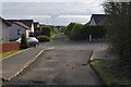
Old Roads
Looking along the line of the Pleasance Road in Queen Margaret Fauld.
Image: © Robert Struthers
Taken: 27 Feb 2016
0.02 miles
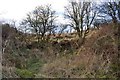
2
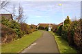
Footpath, Queen Margaret Fauld
This footpath follows the line of an old road which ran from Halbeath via Pleasance Farm to join Whitefield Road. This is the most westerly point which is still visible, the rest has disappeared under a housing estate, along with the farm of Sheephousewell.
Image: © Robert Struthers
Taken: 27 Feb 2016
0.05 miles
3
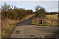
Pleasance Road
This track runs from Queen Margaret Fauld to Halbeath.
Image: © Robert Struthers
Taken: 27 Feb 2016
0.07 miles
4
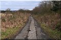
Access Road to Railway
This access road follows the line of the original tram road from Townhill, which passed under the main railway line (now part of the Fife Circle) to meet up with the Halbeath Railway, which ran from Halbeath down to Inverkeithing.
Image: © Robert Struthers
Taken: 27 Feb 2016
0.08 miles
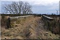
5
End of the line
The navigable part of the trackbed of the Townhill railway line ends here. Beyond this point it has been filled in and turned over to farmland.
Image: © Robert Struthers
Taken: 27 Feb 2016
0.10 miles
6
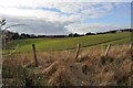
Farmland, Whitefield
Cultivated fields cover over the line of the former Townhill railway, closed in 1976.
Image: © Robert Struthers
Taken: 27 Feb 2016
0.12 miles
7
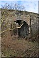
Old Railway Bridge
Under the arch of the bridge are still remnants of the track ballast. The bridge crossed the Townhill railway line.
Image: © Robert Struthers
Taken: 27 Feb 2016
0.13 miles
8
Old Railway Bridge
Quite odd to see such a substantial bridge in the middle of the countryside. It may have served the farm of Easter Whitefield, now long vanished.
Image: © Robert Struthers
Taken: 27 Feb 2016
0.13 miles
9
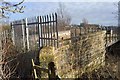
Strictly No Entry
Pedestrian access to this old railway bridge over the Fife Circle is strongly discouraged.
Image: © Robert Struthers
Taken: 27 Feb 2016
0.16 miles
10
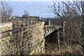
Disused Railway Bridge
This old bridge crosses the Fife Circle line just east of Dunfermline Queen Margaret. In 2010 it had metal side panels (Image), presumably removed in the interim in case they fell on to a passing train.
Image: © Robert Struthers
Taken: 27 Feb 2016
0.16 miles