IMAGES TAKEN NEAR TO
Main Street, DUNFERMLINE, KY12 0HA
Introduction
This page details the photographs taken nearby to Main Street, KY12 0HA by members of the Geograph project.
The Geograph project started in 2005 with the aim of publishing, organising and preserving representative images for every square kilometre of Great Britain, Ireland and the Isle of Man.

There are currently over 7.5m images from over14,400 individuals and you can help contribute to the project by visiting https://www.geograph.org.uk
Image Map
Images are licensed for reuse under creativecommons.org/licenses/by-sa/2.0
Notes
- Clicking on the map will re-center to the selected point.
- The higher the marker number, the further away the image location is from the centre of the postcode.
Image Listing (6 Images Found)
Images are licensed for reuse under creativecommons.org/licenses/by-sa/2.0
Image
Details
Distance
1
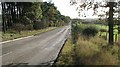
Cairncubie Road
Looking downhill towards Dunfermline.
Image: © Richard Webb
Taken: 31 Oct 2008
0.13 miles
2
Townhill Recreation Park
The Billy Liddell Sports Complex. Billy Liddell the former Liverpool and Scotland footballer was born in Townhill.
Image: © Douglas Nelson
Taken: 17 Mar 2015
0.15 miles
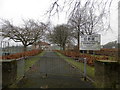
3
Townhill
Adventure playground at Recreation Park in Townhill.
Image: © Paul McIlroy
Taken: 25 Apr 2007
0.18 miles
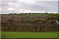
4
Little and large - pylons
Pylons of two transmission lines, of different sizes, running along the course of an old railway. Beyond is part of Townhill Country Park.
Image: © M J Richardson
Taken: 11 Jan 2022
0.19 miles
5
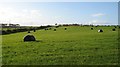
Round silage bales
Field off the Cairncubie Road, with the silage bales left out rather than stacked.
Image: © Richard Webb
Taken: 31 Oct 2008
0.22 miles
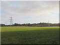
6
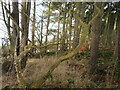
Shelterbelt on Cairncubie Road
A mainly conifer planting separating Cairncubie Road from farmland, between Townhill and Bowershall.
Image: © M J Richardson
Taken: 11 Jan 2022
0.25 miles