IMAGES TAKEN NEAR TO
Main Street, DUNFERMLINE, KY12 0EF
Introduction
This page details the photographs taken nearby to Main Street, KY12 0EF by members of the Geograph project.
The Geograph project started in 2005 with the aim of publishing, organising and preserving representative images for every square kilometre of Great Britain, Ireland and the Isle of Man.

There are currently over 7.5m images from over14,400 individuals and you can help contribute to the project by visiting https://www.geograph.org.uk
Image Map
Images are licensed for reuse under creativecommons.org/licenses/by-sa/2.0
Notes
- Clicking on the map will re-center to the selected point.
- The higher the marker number, the further away the image location is from the centre of the postcode.
Image Listing (10 Images Found)
Images are licensed for reuse under creativecommons.org/licenses/by-sa/2.0
Image
Details
Distance
2
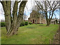
Townhill and Kingseat Parish Church
Townhill and Kingseat parish church was designed by the architect Thomas Ure, and dates from 1893-96. The church began life as a Free Church, but since 1929 it has belonged to the Church of Scotland.
Image: © Euan Nelson
Taken: 20 Mar 2015
0.08 miles
3
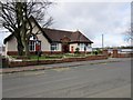
Townhill Library and Community Centre
Townhill Library is one of over 2500 libraries around the world built with money provided by the Dunfermline-born industrialist, Andrew Carnegie, who made his fortune in the American steel industry.
Image: © Euan Nelson
Taken: 20 Mar 2015
0.12 miles
4

Bridge
Where cycleway number one passes under Townhill Road.
Image: © Paul McIlroy
Taken: 25 Apr 2007
0.14 miles
5
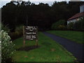
Entrance to Townhill Country Park
Situated in Townhill Wood
Image: © Douglas Nelson
Taken: 9 Sep 2012
0.17 miles
6
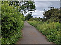
National Cycle Route 1 on old railway track, looking north
Image: © Rob Purvis
Taken: 22 Jun 2018
0.19 miles
7
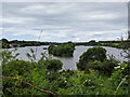
Town Loch seen from the old railway track, now a cycle and foot path
Image: © Rob Purvis
Taken: 22 Jun 2018
0.20 miles
8

Autumnal colours on the Town Loch, Townhill
Autumnal colours reflecting on the loch.
Image: © edward mcmaihin
Taken: 31 Oct 2010
0.21 miles
9
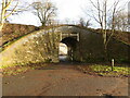
Bridge under an old railway
The railway was the North British Railway, West of Fife Branch. The path leads through to Loch Street, from the Town Loch which is behind the photographer
Image: © M J Richardson
Taken: 11 Jan 2022
0.22 miles
10
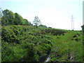
Grazing and pylon, South Bellyeoman
Off Kingseat Road.
Image: © JThomas
Taken: 25 May 2017
0.24 miles