IMAGES TAKEN NEAR TO
Fairways, DUNFERMLINE, KY12 0DX
Introduction
This page details the photographs taken nearby to Fairways, KY12 0DX by members of the Geograph project.
The Geograph project started in 2005 with the aim of publishing, organising and preserving representative images for every square kilometre of Great Britain, Ireland and the Isle of Man.

There are currently over 7.5m images from over14,400 individuals and you can help contribute to the project by visiting https://www.geograph.org.uk
Image Map
Images are licensed for reuse under creativecommons.org/licenses/by-sa/2.0
Notes
- Clicking on the map will re-center to the selected point.
- The higher the marker number, the further away the image location is from the centre of the postcode.
Image Listing (4 Images Found)
Images are licensed for reuse under creativecommons.org/licenses/by-sa/2.0
Image
Details
Distance
1
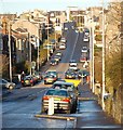
Townhill Road Dunfermline
Townhill Road is a busy route to the north out of Dunfermline, it leads initially to the villages of Townhill, Kingseat and Kelty.
Image: © Paul McIlroy
Taken: 17 Dec 2006
0.21 miles
2
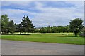
Canmore Golf Course
Looking down across the tee for the fourth hole. A sign at the entrance warns drivers to watch out for golfers driving off - the entrance road crosses the fairway.
Image: © Robert Struthers
Taken: 23 May 2014
0.23 miles
3
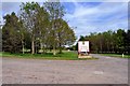
Canmore Golf Club
Entrance to Canmore Golf Club. The club has been at this site since 1902.
Image: © Robert Struthers
Taken: 23 May 2014
0.24 miles
4
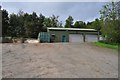
Now That's What I Call A Shed
Presumably this is where the greenkeepers store the equipment for keeping Canmore Golf Club's course in pristine condition.
Image: © Robert Struthers
Taken: 23 May 2014
0.24 miles