IMAGES TAKEN NEAR TO
High Street, KIRKCALDY, KY1 1JW
Introduction
This page details the photographs taken nearby to High Street, KY1 1JW by members of the Geograph project.
The Geograph project started in 2005 with the aim of publishing, organising and preserving representative images for every square kilometre of Great Britain, Ireland and the Isle of Man.

There are currently over 7.5m images from over14,400 individuals and you can help contribute to the project by visiting https://www.geograph.org.uk
Image Map
Images are licensed for reuse under creativecommons.org/licenses/by-sa/2.0
Notes
- Clicking on the map will re-center to the selected point.
- The higher the marker number, the further away the image location is from the centre of the postcode.
Image Listing (160 Images Found)
Images are licensed for reuse under creativecommons.org/licenses/by-sa/2.0
Image
Details
Distance
2
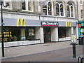
McDonald's, Kirkcaldy
This McDonald's is one of three located in Kirkcaldy, known affectionately in the area as the lang toun. The branch is situated in the town centre (just at the corner of Kirk Wynd and at the end of the high street pedestrian area) and is by far their biggest and busiest in the town.
Image: © Ian Thomson
Taken: 6 Mar 2008
0.02 miles
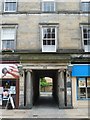
3
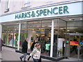
Marks and Spencer, 166 High Street, Kirkcaldy
This is a historic building that the M&S store has occupied since opening in 1937. The building was once the site of the former Kirkcaldy Town House and Clock from 1827-1935.
Image: © Ian Thomson
Taken: 3 Mar 2008
0.03 miles
4
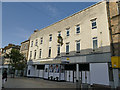
Kirkcaldy High Street - former Marks and Spencer store
Only the name on the clock now gives away the former identity of this vacant shop. See Image for when it was open, and a history of the site.
Image: © Stephen Craven
Taken: 28 Jun 2019
0.03 miles
5
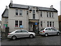
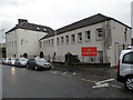
Former Drill Hall, Kirkcaldy
The image displays the 1913 frontage of the drill hall. The units based there were a company of the Royal Garrison Artillery, Black Watch and Highland Cyclists. The Fife and Forfar Yeomanry used it as a drill station.
Image: © Douglas Nelson
Taken: 6 Nov 2014
0.03 miles
6
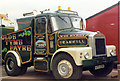
Kirkcaldy.
The other "Tug", previously referred to. Incidentally, the square is strictly a calculated guess, again.
Image: © Ron Hann
Taken: Unknown
0.04 miles
7
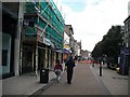
High Street, Kirkcaldy
Pedestrianised shopping street, quiet on a Sunday morning.
Image: © Richard Webb
Taken: 20 Sep 2009
0.04 miles
8
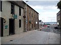
Tollboth Street Kirkcaldy
Some interesting old buildings in this street.
Image: © Douglas Nelson
Taken: 12 Sep 2012
0.04 miles
9
Former drill hall, Kirkcaldy
See Image This image displays a circa 1930 extension to the complex.
Image: © Douglas Nelson
Taken: 6 Nov 2014
0.04 miles
10
Adam Smith Close
Site of Adam Smith's family home where he wrote 'The Wealth Of Nations'. The house was demolished in 1834.
Image: © kim traynor
Taken: 6 Aug 2013
0.04 miles