IMAGES TAKEN NEAR TO
Cullaloe Court, DUNFERMLINE, KY11 9NW
Introduction
This page details the photographs taken nearby to Cullaloe Court, KY11 9NW by members of the Geograph project.
The Geograph project started in 2005 with the aim of publishing, organising and preserving representative images for every square kilometre of Great Britain, Ireland and the Isle of Man.

There are currently over 7.5m images from over14,400 individuals and you can help contribute to the project by visiting https://www.geograph.org.uk
Image Map
Images are licensed for reuse under creativecommons.org/licenses/by-sa/2.0
Notes
- Clicking on the map will re-center to the selected point.
- The higher the marker number, the further away the image location is from the centre of the postcode.
Image Listing (13 Images Found)
Images are licensed for reuse under creativecommons.org/licenses/by-sa/2.0
Image
Details
Distance
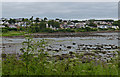
1
Sealstrand at Dalgety Bay
Looking west from the entrance to the Crow Hill wood.
Image: © M J Richardson
Taken: 15 Mar 2017
0.19 miles
2
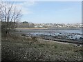
Dalgety Bay
The term "Dalgety Bay" applies both to this one bay, and to the much more larger town which extends westwards to include a number of other bays on the north shore of the Firth of Forth.
Image: © Oliver Dixon
Taken: 22 Mar 2022
0.20 miles
3
Sealstrand at Dalgety Bay
A cul-de-sac, with a path leading through to Crow Hill wood and the Fife Coastal Path.
Image: © M J Richardson
Taken: 15 Mar 2017
0.20 miles
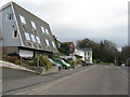
4

Green space in Hillend Industrial Estate
A surprisingly verdant landscape to find in an industrial estate. The enclosure top right is a recycling centre, a fairly recent addition to the landscape.
Image: © Robert Struthers
Taken: 4 Oct 2014
0.21 miles
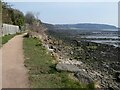
5
Dalgety Bay along the Fife coast
Viewed from the Fife Coastal Path in the Ross Plantation.
Image: © Mat Fascione
Taken: 22 Jul 2019
0.21 miles
6
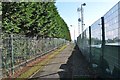
Hillend Industrial Estate Footpath
Hillend Industrial Estate is a maze of access roads and footpaths.
Image: © Robert Struthers
Taken: 4 Oct 2014
0.21 miles
7
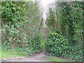
Path into Crow Hill woods
At the end of the Sealstrand cul-de-sac.
Image: © M J Richardson
Taken: 15 Mar 2017
0.22 miles
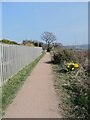
8
Fife Coastal Path at Dalgety Bay
The Fife Coastal Path runs at this point in common with National Cycle Network route 76. The headland of Braefoot Point in the distance.
Image: © Oliver Dixon
Taken: 22 Mar 2022
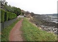
0.22 miles
9
Fife Coastal Path at Dalgety Bay
The Fife Coastal Path runs at this point in common with National Cycle Network route 76.
Image: © Oliver Dixon
Taken: 22 Mar 2022
0.23 miles
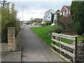
10
Fife Coastal Path
The usual bottom of the garden footpath. The path runs between houses and Dalgety Bay itself. Heading towards Crow Hill Wood.
Image: © Richard Webb
Taken: 7 Dec 2008
0.23 miles