IMAGES TAKEN NEAR TO
Fillan Street, DUNFERMLINE, KY11 8ZB
Introduction
This page details the photographs taken nearby to Fillan Street, KY11 8ZB by members of the Geograph project.
The Geograph project started in 2005 with the aim of publishing, organising and preserving representative images for every square kilometre of Great Britain, Ireland and the Isle of Man.

There are currently over 7.5m images from over14,400 individuals and you can help contribute to the project by visiting https://www.geograph.org.uk
Image Map
Images are licensed for reuse under creativecommons.org/licenses/by-sa/2.0
Notes
- Clicking on the map will re-center to the selected point.
- The higher the marker number, the further away the image location is from the centre of the postcode.
Image Listing (17 Images Found)
Images are licensed for reuse under creativecommons.org/licenses/by-sa/2.0
Image
Details
Distance

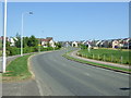
2

Wallace Grange
New housing development off Dunlin Drive, Dunfermline.
Image: © JThomas
Taken: 25 May 2017
0.13 miles

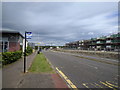
6
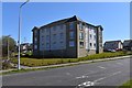
New Housing off Linburn Road
Modern apartment block, latest addition to the Dunfermline East expansion area.
Image: © Robert Struthers
Taken: 19 Apr 2020
0.16 miles
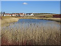
7
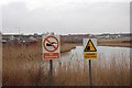
Drainage Pond
Part of the infrastructure for the large number of new houses which are being built in the next square east.
Image: © Paul McIlroy
Taken: 4 Feb 2007
0.17 miles
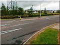
9
Bus stop opposite new housing being built on Linburn Road, looking north
Image: © Rob Purvis
Taken: 22 Jun 2018
0.20 miles
10
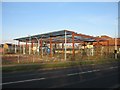
Construction Work
New shopping or food retail units being built on Linburn Road.
Image: © Robert Struthers
Taken: 17 Feb 2013
0.22 miles