IMAGES TAKEN NEAR TO
Overton Court, DUNFERMLINE, KY11 8TY
Introduction
This page details the photographs taken nearby to Overton Court, KY11 8TY by members of the Geograph project.
The Geograph project started in 2005 with the aim of publishing, organising and preserving representative images for every square kilometre of Great Britain, Ireland and the Isle of Man.

There are currently over 7.5m images from over14,400 individuals and you can help contribute to the project by visiting https://www.geograph.org.uk
Image Map
Images are licensed for reuse under creativecommons.org/licenses/by-sa/2.0
Notes
- Clicking on the map will re-center to the selected point.
- The higher the marker number, the further away the image location is from the centre of the postcode.
Image Listing (12 Images Found)
Images are licensed for reuse under creativecommons.org/licenses/by-sa/2.0
Image
Details
Distance
2
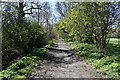
Old Track
An old road, turned footpath. It runs parallel to Carnegie Avenue.
Image: © Robert Struthers
Taken: 19 Apr 2020
0.09 miles

4
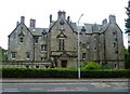
Pitreavie Castle
The site featured prominently in the Battle of Inverkeithing. For more information, see the relevant entry in the Annals of Dunfermline (1879) via the following http://www.tulbol.demon.co.uk/dunfermline/annals11.htm where it is referred to as the Battle of Pitreavie.
"17th July, 1651, being a thursday, cromwell's armie landit heir, who, on the sabbath yreftir, being the 20 day of the sd month, battell being beside pitreavie, killed an cutt manie of or men, robbed and plunderit all."
-- Kirk Session Records of Dunfermline
Image: © kim traynor
Taken: 7 Jul 2011
0.16 miles
6
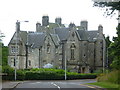
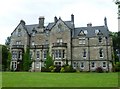
Pitreavie Castle
Late-Victorian edifice on the site of Pitreavie Castle where the last fighting took place in the Battle of Inverkeithing in 1651. http://en.wikipedia.org/wiki/Pitreavie_Castle
Image: © kim traynor
Taken: 7 Jul 2011
0.17 miles
7
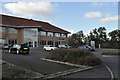
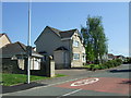
Largo House at Pitreavie Business Park
One of many buildings constructed on the periphery of Dunfermline in the hope of attracting businesses. This one is at least partly occupied by one of the Scottish clearing banks.
Image: © Robert Struthers
Taken: 7 Oct 2011
0.21 miles
8
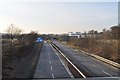
Scotland's Shortest Motorway? (Part 1)
Looking west along the A823(M). The white and blue building on the right is occupied by Sky Television.
Image: © Robert Struthers
Taken: 20 Feb 2010
0.22 miles
9
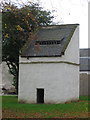
Old Dovecot
This old dovecot is in the grounds of the former Pitreavie Castle estate.
Image: © Robert Struthers
Taken: 9 Nov 2007
0.22 miles
10
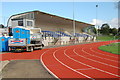
Pitreavie Stadium
Situated at Pitreavie Playing Fields, there has been an athletics track since 1954, it is used by Pitreavie AC and Dunfermline & West Fife AC.
Image: © Paul McIlroy
Taken: 9 Oct 2006
0.23 miles