IMAGES TAKEN NEAR TO
Grange Park, DUNFERMLINE, KY11 8QQ
Introduction
This page details the photographs taken nearby to Grange Park, KY11 8QQ by members of the Geograph project.
The Geograph project started in 2005 with the aim of publishing, organising and preserving representative images for every square kilometre of Great Britain, Ireland and the Isle of Man.

There are currently over 7.5m images from over14,400 individuals and you can help contribute to the project by visiting https://www.geograph.org.uk
Image Map
Images are licensed for reuse under creativecommons.org/licenses/by-sa/2.0
Notes
- Clicking on the map will re-center to the selected point.
- The higher the marker number, the further away the image location is from the centre of the postcode.
Image Listing (19 Images Found)
Images are licensed for reuse under creativecommons.org/licenses/by-sa/2.0
Image
Details
Distance
1
Keir Hardie Terrace
Council housing built in the 1960s and 1970s, now largely owner occupiers.
Image: © Paul McIlroy
Taken: 26 Mar 2008
0.05 miles
2
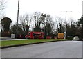
Snack van
This snack van in Pitreavie Business Park, Dunfermline, does a constant trade from passing traffic.
Image: © Bill Kasman
Taken: 20 Feb 2019
0.06 miles
3
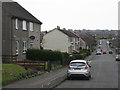
Keir Hardie Terrace
Ex-council housing in south Dunfermline.
Image: © M J Richardson
Taken: 25 Mar 2013
0.07 miles
4
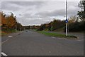
Pitreavie Way
This stub of dual-carriageway seems over-specified as an access road to an industrial estate - possibly it was meant to be part of a larger project.
Image: © Robert Struthers
Taken: 28 Oct 2011
0.07 miles
5
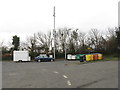
Assorted facilities at Pitreavie
Mobile snack bar, waste recycling bins and mobile telephone mast.
Image: © M J Richardson
Taken: 25 Mar 2013
0.07 miles
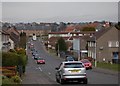
6
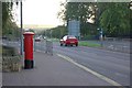
Queensferry Road
This red car is travelling south out of Dunfermline where Hospital Hill becomes Queensferry Road [A823]
Image: © Paul McIlroy
Taken: 9 Oct 2006
0.14 miles
7
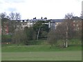
Flats
Former M.O.D. research establishment converted into flats.
Image: © Paul McIlroy
Taken: 4 Mar 2006
0.14 miles
9
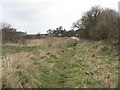
Footpath behind McLelland Crescent
Wasteland behind Pitreavie Crescent Industrial Estate.
Image: © M J Richardson
Taken: 25 Mar 2013
0.16 miles
10
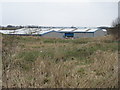
Industrial units at Pitreavie Crescent
Seen from the footpath at the rear, by McLelland Crescent.
Image: © M J Richardson
Taken: 25 Mar 2013
0.17 miles