IMAGES TAKEN NEAR TO
Manor Gardens, DUNFERMLINE, KY11 8PN
Introduction
This page details the photographs taken nearby to Manor Gardens, KY11 8PN by members of the Geograph project.
The Geograph project started in 2005 with the aim of publishing, organising and preserving representative images for every square kilometre of Great Britain, Ireland and the Isle of Man.

There are currently over 7.5m images from over14,400 individuals and you can help contribute to the project by visiting https://www.geograph.org.uk
Image Map
Images are licensed for reuse under creativecommons.org/licenses/by-sa/2.0
Notes
- Clicking on the map will re-center to the selected point.
- The higher the marker number, the further away the image location is from the centre of the postcode.
Image Listing (17 Images Found)
Images are licensed for reuse under creativecommons.org/licenses/by-sa/2.0
Image
Details
Distance

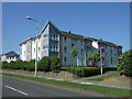
3
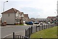
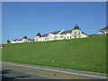
Bergen Drive, Dunfermline.
New housing at Bergen Drive.
Image: © edward mcmaihin
Taken: 21 May 2010
0.14 miles
4
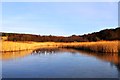
Frozen Pond
The iced over pond at Calais Muir Wood.
Image: © Robert Struthers
Taken: 7 Jan 2018
0.15 miles
5
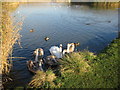
Swans on the Scrounge
The pond on the edge of Calais Muir Wood is well populated with bird life. Any approach by a human results in a mass migration towards him/her, in the hope of getting fed!
Image: © Robert Struthers
Taken: 15 Nov 2007
0.15 miles
6
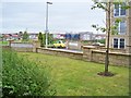
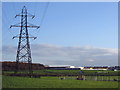
View From Bittern Court
The Dunfermline Eastern Expansion (or 'DEX' if you prefer) is the name for the rampant house and amenity building to the east of the town. Here, this shot looks towards Linburn Road which could be defined as the western border of the DEX.
Image: © James T M Towill
Taken: 6 Aug 2010
0.19 miles
8
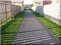
Footpath in Duloch Estate
Vandals have already snapped off the saplings planted along this path.
Image: © Robert Struthers
Taken: 15 Nov 2007
0.21 miles
9
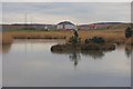
Drainage Pond
This pond in Duloch Park was created by flooding a disused quarry.
Image: © Paul McIlroy
Taken: 25 Jan 2007
0.21 miles
10
Flats on Bittern Court
View over National Cycle Route 1 from Linburn Road.
Image: © JThomas
Taken: 25 May 2017
0.21 miles