IMAGES TAKEN NEAR TO
DUNFERMLINE, KY11 8HP
Introduction
This page details the photographs taken nearby to KY11 8HP by members of the Geograph project.
The Geograph project started in 2005 with the aim of publishing, organising and preserving representative images for every square kilometre of Great Britain, Ireland and the Isle of Man.

There are currently over 7.5m images from over14,400 individuals and you can help contribute to the project by visiting https://www.geograph.org.uk
Image Map
Images are licensed for reuse under creativecommons.org/licenses/by-sa/2.0
Notes
- Clicking on the map will re-center to the selected point.
- The higher the marker number, the further away the image location is from the centre of the postcode.
Image Listing (30 Images Found)
Images are licensed for reuse under creativecommons.org/licenses/by-sa/2.0
Image
Details
Distance
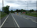
1

Speeding? Watch Out!
Average speed cameras keep an eye on the M90 during construction work. Lots and lots of new signs are being installed, to feed us useful information like "Check Your Fuel" and "Keep Your Distance".
Image: © Robert Struthers
Taken: 17 Mar 2012
0.05 miles
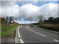
2
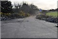
Old Junction
This scabby piece of road runs from the junction of Aberdour Road and the B981 towards the M90; during construction of the motorway this was one of the temporary junctions.
Image: © Robert Struthers
Taken: 17 Mar 2012
0.06 miles
4

Old Access Road
The M90 was constructed in several stages, and one early section terminated at the junction between the B916 and B981, via this now overgrown and mossy bit of road, littered with piles of concrete kerb sections.
Image: © Robert Struthers
Taken: 28 Apr 2018
0.07 miles
5
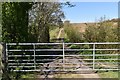
Farm Track
Part of Fife's Core Path network.
Image: © Robert Struthers
Taken: 19 Apr 2020
0.07 miles
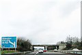
7
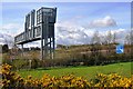
Motorway Sign Gantry
Part of the network of sign gantries that litter the M90 as part of the 'Intelligent Transport System'. In addition to direction signs, the gantries also carry Variable Message Signs, conveying messages of dubious usefulness.
Image: © Robert Struthers
Taken: 28 Apr 2018
0.08 miles
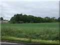
9
The B981 heading for Crossgates in Fife
Near Duloch.
Image: © James Denham
Taken: 26 Apr 2010
0.10 miles
10

Utility Buildings on M90
These buildings of unknown purpose are only accessible from the M90, by authorised vehicles only. Possibly to do with the adjacent motorway signal gantry. This picture was taken from the old access road which was once the terminus for the M90.
Image: © Robert Struthers
Taken: 28 Apr 2018
0.10 miles